10.9 km
~2 hrs 45 min
348 m
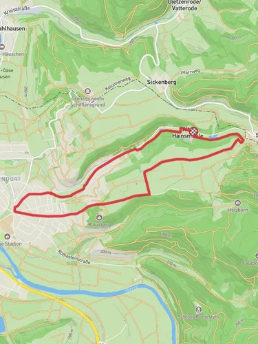
“Explore Werra-Meißner-Kreis's natural beauty and history on this scenic 11 km loop with Schloss Rothestein.”
Starting near Werra-Meißner-Kreis, Germany, this 11 km (approximately 6.8 miles) loop trail offers a moderate challenge with an elevation gain of around 300 meters (approximately 984 feet). The trailhead is conveniently accessible by both car and public transport. If driving, you can park near the Schloss Rothestein, a historic castle that serves as a significant landmark in the area. For those using public transport, the nearest train station is in Bad Sooden-Allendorf, from where you can take a local bus or taxi to the trailhead.
### Trail Overview
The trail begins with a gentle ascent through a mixed forest, offering a serene start to your hike. As you progress, you'll encounter a variety of flora, including oak, beech, and pine trees. The forest floor is often carpeted with wildflowers in the spring and summer, adding a splash of color to your journey.
### Key Landmarks and Points of Interest
Schloss Rothestein: About 2 km (1.2 miles) into the hike, you'll reach Schloss Rothestein. This historic castle, built in the late 19th century, offers panoramic views of the Werra Valley. It's worth taking a short break here to explore the castle grounds and enjoy the vistas.
Hainbachtal Valley: As you continue, the trail descends into the Hainbachtal Valley. This section is particularly scenic, with a babbling brook running alongside the path. The valley is home to a variety of wildlife, including deer, foxes, and numerous bird species. Keep your eyes peeled for kingfishers and herons near the water.
### Elevation and Terrain
The trail features a mix of terrains, from well-maintained forest paths to rocky sections that require careful footing. The most significant elevation gain occurs in the first half of the hike, with a steady climb that can be challenging but manageable for most hikers. The second half of the trail is predominantly downhill, offering a more relaxed return to the starting point.
### Historical Significance
The region around Werra-Meißner-Kreis is steeped in history. The trail itself passes through areas that were once part of ancient trade routes. Schloss Rothestein, with its neo-Gothic architecture, stands as a testament to the area's rich cultural heritage. The castle was originally built as a hunting lodge and later expanded, reflecting the opulence of its era.
### Navigation and Safety
For navigation, it's highly recommended to use the HiiKER app, which provides detailed maps and real-time updates. The trail is well-marked, but having a reliable navigation tool ensures you stay on track, especially in the more remote sections of the forest.
### Getting There
To reach the trailhead by car, set your GPS to Schloss Rothestein, 37242 Bad Sooden-Allendorf, Germany. Ample parking is available near the castle. If using public transport, take a train to Bad Sooden-Allendorf station. From there, local buses or taxis can take you directly to the trailhead.
This trail offers a perfect blend of natural beauty, historical landmarks, and moderate physical challenge, making it an ideal choice for hikers looking to explore the scenic and culturally rich region of Werra-Meißner-Kreis.
Reviews
User comments, reviews and discussions about the Schloss Rothestein via Rundweg Hainbachtal, Germany.
5.0
average rating out of 5
1 rating(s)


