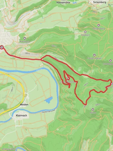
8.1 km
~2 hrs 3 min
266 m
“The Rundweg Joggelibrunnen Loop offers a scenic 8 km hike with diverse landscapes and historical landmarks.”
Starting near the picturesque Werra-Meißner-Kreis in Germany, this 8 km (approximately 5 miles) loop trail offers a delightful mix of natural beauty and moderate physical challenge. With an elevation gain of around 200 meters (656 feet), the Rundweg Joggelibrunnen Loop is perfect for hikers looking for a medium-difficulty trek.
### Getting There To reach the trailhead, you can drive or use public transport. If driving, set your GPS to the nearest known address: Am Anger, 37290 Meißner, Germany. For those using public transport, take a train to Eschwege and then a local bus to Meißner. From there, it's a short walk to the trailhead.
### Trail Overview The trail begins with a gentle ascent through lush forests, offering a serene start to your hike. As you progress, you'll encounter a mix of deciduous and coniferous trees, providing ample shade and a cool environment, especially during the warmer months.
### Significant Landmarks Around the 2 km (1.2 miles) mark, you'll come across the Joggelibrunnen, a charming natural spring that gives the trail its name. This is a great spot to take a short break and enjoy the tranquil sounds of flowing water. The spring is also a historical landmark, as it has been a vital water source for local communities for centuries.
### Flora and Fauna The trail is rich in biodiversity. Keep an eye out for native wildlife such as deer, foxes, and a variety of bird species. The flora is equally impressive, with seasonal wildflowers adding splashes of color to the landscape. In the spring and summer, you'll find an array of blooming flowers, while autumn brings a stunning display of fall foliage.
### Mid-Trail Highlights At approximately 4 km (2.5 miles), you'll reach the highest point of the trail, offering panoramic views of the surrounding countryside. This vantage point is perfect for photography enthusiasts looking to capture the beauty of the Werra-Meißner-Kreis region.
### Navigation and Safety The trail is well-marked, but it's always a good idea to have a reliable navigation tool. HiiKER is an excellent app for this purpose, providing detailed maps and real-time updates. Make sure to wear sturdy hiking boots, as some sections can be rocky and uneven.
### Historical Significance The Werra-Meißner-Kreis region is steeped in history. The trail passes near several ancient sites, including remnants of old settlements and historical markers that tell the story of the area's past. These landmarks offer a fascinating glimpse into the lives of those who inhabited the region long before modern times.
### Final Stretch As you descend back towards the trailhead, the path winds through open meadows and small streams, offering a peaceful end to your hike. The final 2 km (1.2 miles) are relatively flat, making for an easy and enjoyable finish.
This loop trail is a wonderful way to experience the natural and historical richness of the Werra-Meißner-Kreis region. Whether you're a seasoned hiker or a casual walker, the Rundweg Joggelibrunnen Loop offers something for everyone.
Reviews
User comments, reviews and discussions about the Rundweg Joggelibrunnen Loop, Germany.
5.0
average rating out of 5
3 rating(s)


