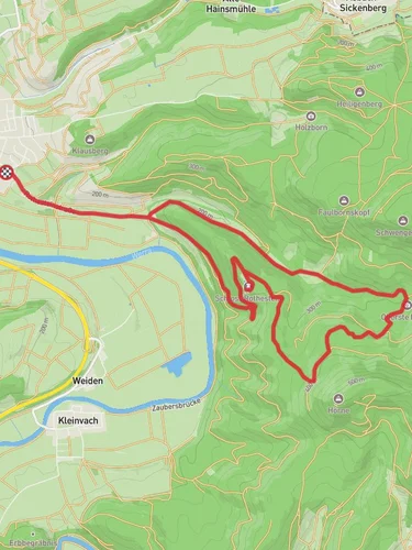
Bad Sooden-Allendorf to Weissenbach via Saelzerweg
13.1 km
~3 hrs 36 min
598 m
“Experience lush forests, historical routes, and stunning Werra Valley views on this rewarding 13 km hike.”
Starting near Werra-Meißner-Kreis, Germany, this 13 km (8 miles) point-to-point trail offers a medium difficulty hike with an elevation gain of approximately 500 meters (1,640 feet). The trailhead is easily accessible by car or public transport, with the nearest significant landmark being the town of Bad Sooden-Allendorf. If you're traveling by train, the Bad Sooden-Allendorf station is well-connected and a short walk from the trailhead.
### Initial Ascent and Forested Pathways
The hike begins with a moderate ascent through lush, forested pathways. As you climb, you'll gain about 200 meters (656 feet) in the first 3 km (1.86 miles). The forest is rich with native flora, including beech and oak trees, and you might spot wildlife such as deer and various bird species. The trail is well-marked, but it's advisable to use HiiKER for navigation to ensure you stay on track.
### Historical Significance
Around the 5 km (3.1 miles) mark, you'll encounter remnants of the Saelzerweg, an ancient salt trading route that dates back to medieval times. This section of the trail is particularly fascinating for history enthusiasts. The Saelzerweg was crucial for the transport of salt, a valuable commodity, and you can still see some of the old markers and boundary stones that delineated the route.
### Scenic Views and Rest Points
As you continue, the trail opens up to offer stunning panoramic views of the Werra Valley. Around the 8 km (5 miles) point, you'll reach a scenic overlook that provides a perfect spot for a rest and some photography. The elevation gain here is more gradual, adding another 150 meters (492 feet) over the next 3 km (1.86 miles).
### Flora and Fauna
The trail then meanders through a mix of open meadows and dense forest. This section is particularly rich in wildflowers during the spring and summer months. Keep an eye out for butterflies and other pollinators that frequent the area. The diversity of plant life is impressive, with everything from wild garlic to rare orchids making an appearance.
### Final Descent and Arrival in Weissenbach
The last 2 km (1.24 miles) involve a gentle descent into the village of Weissenbach. This part of the trail is less strenuous, allowing you to enjoy the serene surroundings as you make your way down. The village itself is quaint and offers a few amenities such as cafes and small shops where you can relax and refresh after your hike.
### Getting Back
For your return journey, public transport options are available from Weissenbach. Buses run regularly to nearby towns, and from there, you can catch a train back to Bad Sooden-Allendorf or other destinations. If you drove to the trailhead, you might consider arranging a taxi or shuttle service for convenience.
This trail offers a blend of natural beauty, historical intrigue, and moderate physical challenge, making it a rewarding experience for hikers of all levels.
Reviews
User comments, reviews and discussions about the Bad Sooden-Allendorf to Weissenbach via Saelzerweg, Germany.
5.0
average rating out of 5
2 rating(s)


