14.8 km
~3 hrs 29 min
318 m
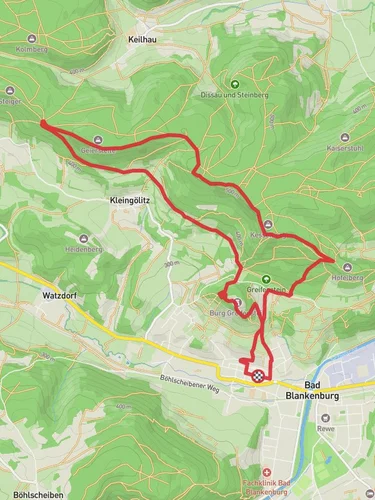
“Experience a moderately challenging 15 km loop trail blending Saalfeld-Rudolstadt's natural beauty and historical intrigue.”
Starting near the picturesque town of Saalfeld-Rudolstadt in Germany, this 15 km (approximately 9.3 miles) loop trail offers a delightful mix of natural beauty and historical intrigue. With an elevation gain of around 300 meters (approximately 984 feet), the trail is rated as medium difficulty, making it suitable for moderately experienced hikers.
### Getting There To reach the trailhead, you can either drive or use public transport. If driving, head towards Saalfeld-Rudolstadt, where ample parking is available near the starting point. For those using public transport, the nearest significant landmark is the Saalfeld (Saale) train station. From there, local buses or a short taxi ride will get you to the trailhead.
### Trail Highlights
#### Natural Beauty The trail meanders through a variety of landscapes, including dense forests, open meadows, and rolling hills. Early in the hike, you'll find yourself surrounded by towering beech and oak trees, providing a serene canopy overhead. As you progress, the forest opens up to reveal expansive meadows, often dotted with wildflowers in the spring and summer months.
#### Wildlife Keep an eye out for local wildlife, including deer, foxes, and a variety of bird species. The area is particularly known for its vibrant birdlife, so bringing a pair of binoculars could enhance your experience.
### Historical Significance
#### Saalfeld Fairy Grottoes One of the most notable landmarks near the trail is the Saalfeld Fairy Grottoes (Feengrotten), located just a short detour from the main path. These former mines are renowned for their colorful mineral formations and have been dubbed the "most colorful grottoes in the world." A visit here offers a fascinating glimpse into the region's mining history.
#### Medieval Ruins Approximately halfway through the hike, you'll come across the ruins of an old medieval castle. Though mostly in ruins, the site offers a tangible connection to the region's storied past. The elevated position of the ruins also provides a fantastic vantage point for panoramic views of the surrounding countryside.
### Navigation and Safety Given the moderate difficulty of the trail, it's advisable to use a reliable navigation tool like HiiKER to ensure you stay on track. The trail is well-marked, but having a digital map can be invaluable, especially in the denser forest sections.
### Practical Tips
#### Footwear and Gear Given the varied terrain, sturdy hiking boots are recommended. The trail can be muddy in sections, particularly after rain, so waterproof footwear is a good idea. A lightweight rain jacket and layered clothing will help you adapt to changing weather conditions.
#### Hydration and Snacks There are no facilities along the trail, so be sure to bring enough water and snacks to sustain you for the duration of the hike. A small backpack with a hydration system can be particularly convenient.
#### Best Time to Hike The trail is accessible year-round, but the best times to hike are late spring through early autumn. During these months, the weather is generally mild, and the natural scenery is at its most vibrant.
By preparing adequately and taking the time to appreciate both the natural and historical elements of the Rundwanderweg 4, you'll be rewarded with a rich and fulfilling hiking experience.
Reviews
User comments, reviews and discussions about the Rundwanderweg 4, Germany.
0.0
average rating out of 5
0 rating(s)
Loading reviews...


