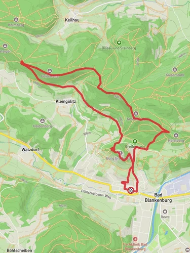
9.2 km
~2 hrs 10 min
207 m
“This 9 km loop near Saalfeld-Rudolstadt blends lush landscapes, historical intrigue, and moderate hiking challenges.”
Starting near the picturesque town of Saalfeld-Rudolstadt in Germany, this 9 km (5.6 miles) loop trail offers a delightful mix of natural beauty and historical intrigue. With an elevation gain of around 200 meters (656 feet), the trail is rated as medium difficulty, making it suitable for moderately experienced hikers.
### Getting There To reach the trailhead, you can either drive or use public transport. If driving, set your GPS to Saalfeld-Rudolstadt, and look for parking near the town center. For those using public transport, take a train to Saalfeld (Saale) station. From there, local buses or a short taxi ride will get you to the trailhead.
### Trail Navigation For navigation, it's highly recommended to use the HiiKER app, which provides detailed maps and real-time updates. This will ensure you stay on the right path and can easily locate points of interest.
### Trail Highlights As you begin your hike, you'll immediately notice the lush greenery that characterizes this region. The trail meanders through dense forests, open meadows, and along serene streams, offering a variety of landscapes to enjoy.
#### Historical Significance One of the most notable aspects of this trail is its proximity to the historic town of Saalfeld. Known for its medieval architecture and the famous Saalfeld Fairy Grottoes, the town adds a layer of historical depth to your hike. The Fairy Grottoes, located just a short detour from the trail, are a series of colorful, mineral-rich caves that have been attracting visitors for centuries.
### Flora and Fauna The trail is a haven for nature enthusiasts. You'll encounter a diverse range of flora, from towering beech and oak trees to vibrant wildflowers that bloom in the spring and summer months. Wildlife is abundant as well; keep an eye out for deer, foxes, and a variety of bird species that inhabit the area.
### Key Landmarks Around the 3 km (1.9 miles) mark, you'll come across a scenic viewpoint that offers panoramic views of the Thuringian Forest. This is an excellent spot to take a break and soak in the natural beauty. Continuing on, at approximately 6 km (3.7 miles), you'll find a charming wooden bridge crossing a babbling brook, another perfect photo opportunity.
### Elevation and Terrain The trail features a mix of gentle inclines and steeper sections, with the most significant elevation gain occurring in the first half of the hike. The terrain is varied, ranging from well-trodden paths to rocky sections, so sturdy hiking boots are recommended.
### Practical Tips - Water and Snacks: There are no facilities along the trail, so bring enough water and snacks to sustain you. - Weather: The weather can be unpredictable, so check the forecast and dress in layers. - Safety: While the trail is well-marked, using the HiiKER app will help you stay on track and avoid any potential detours.
This trail offers a perfect blend of natural beauty, historical context, and moderate physical challenge, making it a rewarding experience for any hiker.
Reviews
User comments, reviews and discussions about the Rundwanderweg 3 and 4, Germany.
0.0
average rating out of 5
0 rating(s)


