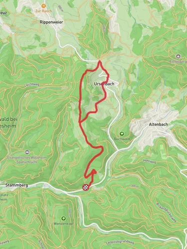
Brandplattenweg, Jagdhaus Fußweg and Oberer Darmuthweg Loop
13.3 km
~3 hrs 40 min
620 m
“Explore a historic 13 km loop near Heidelberg, blending lush forests, wildlife, and panoramic valley views.”
Starting near Rhein-Neckar-Kreis, Germany, the Brandplattenweg, Jagdhaus Fußweg, and Oberer Darmuthweg Loop is a captivating 13 km (8 miles) trail with an elevation gain of approximately 600 meters (1,970 feet). This loop trail offers a medium difficulty rating, making it suitable for moderately experienced hikers.
### Getting There To reach the trailhead, you can either drive or use public transport. If driving, set your GPS to the nearest known address: Heidelberg, Germany. From Heidelberg, it's a short drive to the trailhead. For those using public transport, take a train to Heidelberg Hauptbahnhof (Heidelberg Central Station). From there, you can catch a local bus or taxi to the trailhead.
### Trail Overview The loop begins with a gentle ascent through dense forests, offering a serene start to your hike. As you progress, the trail becomes steeper, leading you to the first significant landmark, the Brandplattenweg. This section is known for its lush greenery and occasional sightings of local wildlife, such as deer and various bird species.
### Brandplattenweg Approximately 4 km (2.5 miles) into the hike, you'll reach the Brandplattenweg. This part of the trail is characterized by its well-maintained paths and panoramic views of the surrounding valleys. The elevation gain here is around 200 meters (656 feet), providing a moderate challenge. Keep an eye out for the diverse flora, including oak and beech trees, which are abundant in this region.
### Jagdhaus Fußweg Continuing on, you'll transition into the Jagdhaus Fußweg. This section is historically significant, as it was once used by hunters in the region. The trail here is relatively flat, offering a brief respite from the earlier ascent. You'll pass by an old hunting lodge, a relic from the 18th century, which adds a touch of historical intrigue to your hike. This part of the trail is about 3 km (1.9 miles) long and is perfect for a quick rest and some photography.
### Oberer Darmuthweg The final section of the loop is the Oberer Darmuthweg. This part of the trail is the most challenging, with an elevation gain of approximately 400 meters (1,312 feet) over 6 km (3.7 miles). The path is rocky and steep, requiring careful navigation. Using HiiKER for real-time trail navigation can be particularly helpful here. As you ascend, you'll be rewarded with breathtaking views of the Odenwald forest and the Neckar River.
### Wildlife and Nature Throughout the hike, you'll encounter a variety of wildlife. The dense forests are home to foxes, wild boars, and numerous bird species. The flora is equally diverse, with seasonal wildflowers adding bursts of color to the landscape. In the spring and summer, the trail is particularly vibrant, making it a great time for nature enthusiasts to visit.
### Historical Significance The region around Rhein-Neckar-Kreis has a rich history dating back to Roman times. The trail itself passes through areas that were once significant hunting grounds for local nobility. The old hunting lodge on the Jagdhaus Fußweg is a testament to this historical legacy, offering a glimpse into the past.
### Preparation and Tips Given the medium difficulty rating, it's advisable to wear sturdy hiking boots and bring plenty of water. The trail can be slippery in wet conditions, so check the weather forecast before heading out. A map or a navigation tool like HiiKER is essential for staying on track, especially in the more challenging sections of the Oberer Darmuthweg.
This 13 km loop offers a perfect blend of natural beauty, historical significance, and moderate physical challenge, making it a rewarding experience for any hiker.
Reviews
User comments, reviews and discussions about the Brandplattenweg, Jagdhaus Fußweg and Oberer Darmuthweg Loop, Germany.
5.0
average rating out of 5
6 rating(s)


