14.4 km
~3 hrs 22 min
293 m
“The Neyetalsperre Circle is a 14 km scenic loop in Germany, blending natural beauty and historical landmarks.”
Starting near Oberbergischer Kreis in Germany, the Neyetalsperre Circle is a picturesque loop trail that spans approximately 14 kilometers (8.7 miles) with an elevation gain of around 200 meters (656 feet). This medium-difficulty trail offers a blend of natural beauty, historical significance, and a variety of landscapes that make it a rewarding experience for hikers.
### Getting There To reach the trailhead, you can drive or use public transport. If driving, set your GPS to Oberbergischer Kreis, and look for parking near the Neyetalsperre dam. For those using public transport, take a train to Gummersbach station and then a bus towards Wipperfürth, alighting at the Neyetalsperre stop. From there, it's a short walk to the trailhead.
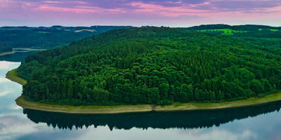
### Trail Overview The Neyetalsperre Circle begins near the Neyetalsperre dam, a significant landmark in the region. The dam itself is an impressive structure, built in the early 20th century to provide water supply and flood protection. As you start your hike, you'll be greeted by the serene waters of the reservoir, which reflect the surrounding forested hills.
### Key Sections and Landmarks - Neyetalsperre Dam (0 km / 0 miles): The starting point of your hike. Take a moment to appreciate the engineering marvel and the tranquil reservoir. - Forest Path (2 km / 1.2 miles): The trail meanders through dense forests, offering shade and a cool atmosphere. Keep an eye out for local wildlife such as deer and various bird species. - Scenic Overlook (5 km / 3.1 miles): Approximately 5 kilometers into the hike, you'll reach a scenic overlook that provides panoramic views of the reservoir and surrounding hills. This is a great spot for a break and some photos. - Historical Ruins (7 km / 4.3 miles): Midway through the trail, you'll come across the ruins of an old mill, which dates back to the 18th century. This site offers a glimpse into the region's industrial past. - Meadowlands (10 km / 6.2 miles): As you continue, the trail opens up into meadowlands, where you can see a variety of wildflowers, especially in the spring and summer months. This section is relatively flat and offers a nice contrast to the forested areas. - Return to Dam (14 km / 8.7 miles): The final stretch brings you back to the Neyetalsperre dam, completing the loop.
### Navigation and Safety For navigation, it's highly recommended to use the HiiKER app, which provides detailed maps and real-time updates. The trail is well-marked, but having a reliable navigation tool ensures you stay on track.
### Flora and Fauna The Neyetalsperre Circle is rich in biodiversity. The forested sections are home to oak, beech, and pine trees, while the meadowlands boast a variety of wildflowers. Wildlife enthusiasts might spot deer, foxes, and a range of bird species, including woodpeckers and owls.
### Historical Significance The Neyetalsperre dam itself is a historical landmark, constructed between 1905 and 1908. It played a crucial role in the region's development by providing a reliable water supply and flood control. The ruins of the old mill along the trail further add to the historical tapestry, offering insights into the area's industrial heritage.
### Preparation Tips - Footwear: Sturdy hiking boots are recommended due to the varied terrain. - Weather: Check the weather forecast before you go, as conditions can change rapidly. - Supplies: Carry enough water and snacks, especially since there are limited facilities along the trail. - Clothing: Dress in layers to accommodate changing temperatures and conditions.
The Neyetalsperre Circle offers a well-rounded hiking experience with its mix of natural beauty, historical landmarks, and diverse landscapes. Whether you're a seasoned hiker or a casual walker, this trail provides a fulfilling adventure in the heart of Germany's scenic countryside.
Reviews
User comments, reviews and discussions about the Neyetalsperre Circle, Germany.
0.0
average rating out of 5
0 rating(s)


