10.9 km
~2 hrs 25 min
150 m
“This 11 km loop near Amberg-Sulzbach blends natural beauty with historical intrigue for moderately fit hikers.”
Starting near the picturesque town of Amberg-Sulzbach in Germany, this 11 km (approximately 6.8 miles) loop trail offers a delightful mix of natural beauty and historical intrigue. With an elevation gain of around 100 meters (328 feet), it is rated as medium difficulty, making it accessible for most hikers with a moderate level of fitness.
### Getting There To reach the trailhead, you can either drive or use public transport. If driving, set your GPS to Amberg-Sulzbach, and look for parking near the town center. For those using public transport, take a train to Amberg station, which is well-connected to major cities like Nuremberg and Regensburg. From the station, local buses or a short taxi ride will get you to the trailhead.
### Trail Highlights #### Nature and Wildlife The trail meanders through a variety of landscapes, including dense forests, open meadows, and serene streams. Keep an eye out for local wildlife such as deer, foxes, and a variety of bird species. The flora is equally diverse, with seasonal wildflowers adding splashes of color to the verdant surroundings.
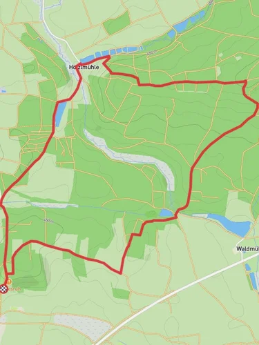
#### Historical Significance Amberg-Sulzbach is steeped in history, and this trail offers glimpses into its past. About 3 km (1.9 miles) into the hike, you'll come across the ruins of an old mill, known locally as Hoelzlmuehl. This mill dates back to the medieval period and offers a fascinating look into the region's historical reliance on water-powered industry.
### Navigation and Waypoints Using HiiKER for navigation is highly recommended. The app provides detailed maps and real-time updates, ensuring you stay on track. Key waypoints to note include:
- Start Point: Near Amberg-Sulzbach town center. - Hoelzlmuehl Ruins: Approximately 3 km (1.9 miles) from the start. - Scenic Overlook: Around 7 km (4.3 miles) into the hike, offering panoramic views of the surrounding countryside. - Return to Start: Completing the loop back to Amberg-Sulzbach.
### What to Bring Given the moderate difficulty and length of the trail, it's advisable to bring:
- Comfortable hiking boots - A daypack with water and snacks - A map or GPS device (HiiKER recommended) - Weather-appropriate clothing - A camera for capturing the stunning scenery and historical sites
### Safety Tips While the trail is well-marked, always stay aware of your surroundings. The elevation gain is modest, but some sections can be slippery, especially after rain. Make sure to check the weather forecast before heading out and inform someone of your plans.
This trail offers a perfect blend of natural beauty and historical exploration, making it a rewarding experience for any hiker.
Reviews
User comments, reviews and discussions about the Hoelzlmuehlweg, Germany.
0.0
average rating out of 5
0 rating(s)


