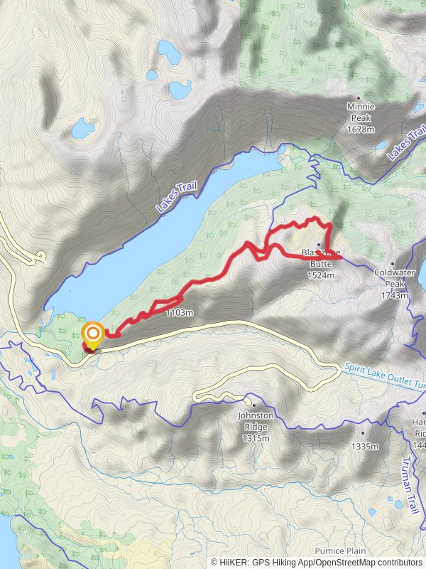
Blastzone Butte via South Coldwater Trail
Gifford Pinchot National Forest · Cowlitz County, Washington
14.3 km
~4 hrs 18 min
862 m
“Embark on the Blastzone Butte loop for a rewarding hike through lush forests and historic eruption sites.”
Starting your hike near Cowlitz County, Washington, the Blastzone Butte via South Coldwater Trail is a captivating loop trail that spans approximately 14 kilometers (8.7 miles) with an elevation gain of around 800 meters (2,625 feet). This trail offers a medium difficulty rating, making it suitable for moderately experienced hikers.
### Getting There To reach the trailhead, you can drive or use public transport. If driving, head towards the Coldwater Lake Recreation Area, which is the nearest significant landmark. From there, follow the signs to the South Coldwater Trailhead. For those using public transport, the nearest major city is Castle Rock, Washington. From Castle Rock, you can take a local bus or arrange a shuttle service to the Coldwater Lake Recreation Area.
### Trail Overview The trail begins with a gradual ascent through lush forested areas, offering a serene start to your hike. As you progress, the trail opens up to reveal stunning views of the surrounding landscape, including the remnants of the 1980 Mount St. Helens eruption. This area is rich in geological history, and you'll notice the stark contrast between the regenerating forest and the blast zone.
### Significant Landmarks At approximately 3 kilometers (1.9 miles) into the hike, you'll reach the first significant viewpoint, offering panoramic views of Coldwater Lake and the surrounding valleys. This is a great spot to take a break and soak in the scenery.
Continuing on, the trail becomes steeper as you approach the halfway point. Around the 7-kilometer (4.3 miles) mark, you'll reach the summit of Blastzone Butte. Here, the elevation gain is most noticeable, and the views are truly breathtaking. On a clear day, you can see Mount St. Helens, Mount Adams, and even Mount Rainier in the distance.
### Flora and Fauna The trail is home to a diverse range of flora and fauna. In the lower elevations, you'll find dense forests of Douglas fir and western red cedar. As you ascend, the vegetation becomes sparser, with hardy shrubs and wildflowers dotting the landscape. Keep an eye out for local wildlife, including deer, elk, and various bird species. The area is also known for its vibrant wildflower displays in late spring and early summer.
### Historical Significance The region holds significant historical importance due to the 1980 eruption of Mount St. Helens. The trail passes through areas that were directly impacted by the blast, offering a unique opportunity to witness the power of nature and the resilience of the ecosystem. Interpretive signs along the trail provide insights into the eruption and its aftermath, making this hike not only a physical challenge but also an educational experience.
### Navigation and Safety Given the trail's moderate difficulty, it's essential to come prepared. Ensure you have a reliable navigation tool like HiiKER to keep track of your progress and stay on course. The trail is well-marked, but weather conditions can change rapidly, so it's wise to check the forecast and pack accordingly. Bring plenty of water, snacks, and a first aid kit.
### Final Stretch The descent from Blastzone Butte is gradual, allowing you to enjoy the views as you make your way back to the trailhead. The loop nature of the trail means you'll experience new scenery on your return, making the entire hike a dynamic and engaging adventure.
By the time you complete the loop, you'll have traversed a diverse landscape rich in natural beauty and historical significance, making the Blastzone Butte via South Coldwater Trail a memorable and rewarding hike.
Reviews
User comments, reviews and discussions about the Blastzone Butte via South Coldwater Trail, Washington.
5.0
average rating out of 5
7 rating(s)


