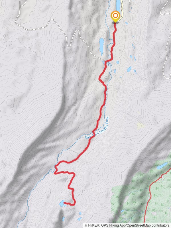
Lake Hessie via China Meadows Road
26.6 km
~1 day 1 hrs
518 m
“Embark on a 27-kilometer trek through lush meadows and alpine vistas to stunning Lake Hessie.”
Starting your adventure near Summit County, Utah, the Lake Hessie via China Meadows Road trail is an out-and-back journey that spans approximately 27 kilometers (around 16.8 miles) with an elevation gain of about 500 meters (1,640 feet). This medium-difficulty trail offers a blend of natural beauty, historical significance, and a moderate challenge suitable for most hikers.
### Getting There To reach the trailhead, you can drive or use public transportation. If driving, head towards Summit County, Utah, and look for the China Meadows Road. The nearest significant landmark is the China Meadows Campground, which serves as a convenient starting point. For those using public transport, the nearest bus stop is in Evanston, Wyoming, from where you can arrange a taxi or rideshare to the trailhead.
### Trail Overview The trail begins at the China Meadows Campground, a well-known spot for camping and fishing. As you set off, you'll find yourself surrounded by lush meadows and dense forests, typical of the Uinta-Wasatch-Cache National Forest. The initial part of the trail is relatively flat, making it a good warm-up for the more challenging sections ahead.
### Significant Landmarks and Nature Around 5 kilometers (3.1 miles) into the hike, you'll encounter the first significant landmark: the East Fork Bear River. This river is a great spot to take a break, enjoy the serene environment, and perhaps even spot some local wildlife like deer or moose. The river crossing is straightforward, but it's always wise to check water levels before proceeding.
Continuing on, the trail begins to ascend more steeply. At approximately 10 kilometers (6.2 miles), you'll reach an elevation gain of about 250 meters (820 feet). Here, the forest opens up to reveal stunning alpine vistas. The flora changes noticeably, with more hardy, high-altitude plants making an appearance.
### Historical Significance This region has a rich history, particularly with the Native American tribes who once roamed these lands. The Uinta Mountains were historically significant for the Ute and Shoshone tribes, who used these trails for hunting and trading. As you hike, you might come across ancient petroglyphs or other remnants of these early inhabitants.
### Final Stretch to Lake Hessie The last 3 kilometers (1.9 miles) to Lake Hessie are the most challenging, with a steeper incline and rocky terrain. However, the effort is well worth it. Upon reaching Lake Hessie, you'll be greeted by crystal-clear waters surrounded by towering peaks. This is an ideal spot for a picnic, some fishing, or simply soaking in the natural beauty.
### Wildlife and Safety The area is home to a variety of wildlife, including black bears, so it's essential to carry bear spray and know how to use it. Smaller animals like marmots and pikas are also common and can often be seen scurrying among the rocks.
### Navigation For navigation, it's highly recommended to use HiiKER, which provides detailed maps and real-time updates. This will help you stay on track and ensure you don't miss any key landmarks or turn-offs.
### Return Journey The return journey follows the same path, allowing you to revisit the beautiful landscapes and perhaps notice things you missed on the way up. Make sure to leave no trace and pack out all your trash to preserve the natural beauty of this incredible trail.
This hike offers a perfect blend of natural beauty, moderate challenge, and historical intrigue, making it a must-do for any avid hiker.
Reviews
User comments, reviews and discussions about the Lake Hessie via China Meadows Road, Utah.
5.0
average rating out of 5
6 rating(s)


