13.5 km
~3 hrs 49 min
676 m
“Experience breathtaking vistas, rich history, and rugged terrain on the captivating 14 km HyMasa-Upper Captain Ahab Loop.”
Starting near Grand County, Utah, the HyMasa, Upper Captain Ahab, and Upper Captain Ahab Loop is a captivating 14 km (approximately 8.7 miles) trail with an elevation gain of around 600 meters (about 1,970 feet). This loop trail is rated as medium difficulty, making it suitable for hikers with some experience.
### Getting There To reach the trailhead, you can drive or use public transportation. If driving, head towards the Amasa Back Parking Lot, located near Kane Creek Blvd, Moab, UT 84532. For those relying on public transport, the nearest bus stop is in Moab, from where you can take a taxi or rideshare service to the trailhead.
### Trail Overview The trail begins with the HyMasa section, which offers a gradual ascent through a rugged landscape characterized by red rock formations and sparse desert vegetation. The first 3 km (1.9 miles) of the trail will see you gaining about 150 meters (492 feet) in elevation. Keep an eye out for the unique rock formations and the occasional sighting of desert wildlife such as lizards and birds of prey.
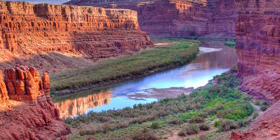
### HyMasa Section As you continue along HyMasa, the trail becomes steeper and more challenging. Around the 5 km (3.1 miles) mark, you'll reach a plateau that offers panoramic views of the surrounding canyons and the Colorado River. This is a great spot to take a break and hydrate. The trail here is well-marked, but it's advisable to use the HiiKER app for navigation to ensure you stay on course.
### Upper Captain Ahab Transitioning to the Upper Captain Ahab section, the trail becomes more technical with rocky terrain and narrow paths. This part of the trail is about 4 km (2.5 miles) long and includes an elevation gain of approximately 200 meters (656 feet). The views here are spectacular, with sweeping vistas of the La Sal Mountains and the Moab Valley. Be cautious of the sharp turns and steep drop-offs.
### Wildlife and Flora The area is home to a variety of wildlife, including mule deer, coyotes, and numerous bird species. The flora is typical of the high desert, with juniper trees, sagebrush, and various cacti dotting the landscape. Spring and fall are the best times to see wildflowers in bloom.
### Historical Significance The region has a rich history, with evidence of Native American habitation dating back thousands of years. Petroglyphs and ancient artifacts have been found in the area, adding a layer of historical intrigue to your hike. The trail also passes near old mining sites, remnants of the area's more recent history.
### Final Stretch The final stretch of the loop brings you back to the starting point via the Lower Captain Ahab trail. This section is about 5 km (3.1 miles) long and descends gradually, offering a more relaxed end to your hike. The descent provides additional views of the canyon and the river, making for a picturesque conclusion to your journey.
### Preparation Tips Given the trail's medium difficulty, it's essential to come prepared. Wear sturdy hiking boots, bring plenty of water, and pack snacks or a light meal. The trail is exposed, so sun protection is crucial. Always check the weather forecast before heading out, as conditions can change rapidly in the desert.
Using the HiiKER app will help you navigate the trail efficiently and ensure you don't miss any key landmarks or viewpoints.
Reviews
User comments, reviews and discussions about the HyMasa, Upper Captain Ahab and Upper Captain Ahab Loop, Utah.
0.0
average rating out of 5
0 rating(s)


