17.9 km
~1 day 0 hrs
927 m
“Amasa Back and Pathole Arch Trail: A challenging 18 km hike with stunning views and rich history.”
Starting near Grand County, Utah, the Amasa Back and Pathole Arch Trail is an 18 km (11.2 miles) out-and-back adventure with an elevation gain of approximately 900 meters (2,950 feet). This trail is rated as medium difficulty, making it suitable for moderately experienced hikers looking for a rewarding challenge.
### Getting There To reach the trailhead, you can drive or use public transport. If driving, head towards Kane Creek Boulevard, which is the nearest significant landmark. From Moab, it's a short drive southwest along Kane Creek Boulevard until you reach the trailhead parking area. For those relying on public transport, local shuttle services from Moab can drop you off near the trailhead.
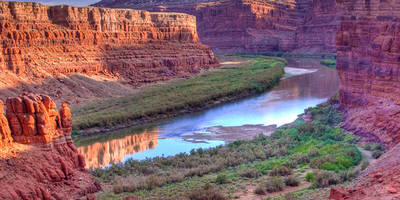
### Trail Overview The trail begins with a steady ascent, offering panoramic views of the Colorado River and the surrounding canyonlands. The initial 3 km (1.9 miles) involve a climb of about 300 meters (985 feet), so be prepared for a bit of a workout right from the start. The terrain is rugged, with rocky paths and occasional loose gravel, so sturdy hiking boots are recommended.
### Key Landmarks and Points of Interest - Amasa Back: At around the 5 km (3.1 miles) mark, you'll reach the Amasa Back viewpoint. This spot offers breathtaking vistas of the Colorado River and the La Sal Mountains in the distance. It's a great place to take a break and soak in the scenery. - Pathole Arch: Continuing on, the trail leads you to Pathole Arch at approximately 9 km (5.6 miles). This natural sandstone arch is a stunning geological formation and a perfect spot for photography. The arch is also a significant landmark, marking the turnaround point of the trail.
### Flora and Fauna The trail traverses a high desert environment, characterized by juniper trees, pinyon pines, and various desert shrubs. Keep an eye out for local wildlife, including mule deer, desert cottontails, and a variety of bird species such as red-tailed hawks and golden eagles. The spring and fall seasons are particularly vibrant, with blooming wildflowers adding splashes of color to the landscape.
### Historical Significance The region around the Amasa Back and Pathole Arch Trail is rich in Native American history. The area was once inhabited by the Ancestral Puebloans, and you may come across ancient petroglyphs and pictographs on some of the rock faces. These historical artifacts offer a glimpse into the lives of the people who once called this rugged landscape home.
### Navigation and Safety Given the rugged terrain and potential for getting off-track, it's advisable to use a reliable navigation tool like HiiKER to stay on course. The trail is well-marked, but having a digital map can provide extra assurance. Carry plenty of water, especially during the hotter months, and be prepared for sudden weather changes, as the high desert climate can be unpredictable.
### Final Stretch The return journey retraces your steps back to the trailhead, offering a different perspective on the stunning landscapes you passed earlier. The descent can be tough on the knees, so take your time and use trekking poles if you have them.
This trail offers a mix of challenging climbs, stunning vistas, and rich historical context, making it a must-do for any avid hiker visiting the Grand County area.
Reviews
User comments, reviews and discussions about the Amasa Back and Pathole Arch Trail, Utah.
0.0
average rating out of 5
0 rating(s)


