10.7 km
~2 hrs 44 min
360 m
“"Explore the Vulkaneifel loop: 11 km of volcanic landscapes, medieval ruins, and rich biodiversity in Germany."”
Starting your hike near the picturesque town of Vulkaneifel, Germany, this 11 km (approximately 6.8 miles) loop trail offers a delightful mix of natural beauty and historical intrigue. With an elevation gain of around 300 meters (approximately 984 feet), this medium-difficulty trail is perfect for those looking to immerse themselves in the unique volcanic landscape of the Eifel region.
### Getting There To reach the trailhead, you can either drive or use public transport. If you're driving, set your GPS to the town of Daun, which is the nearest significant landmark. From Daun, follow the signs to the Vulkaneifel area. For those using public transport, take a train to Gerolstein station and then a local bus to Daun. From Daun, it's a short taxi ride or a local bus to the trailhead.
### Trail Highlights #### Auberg Starting from the trailhead, the first significant landmark you'll encounter is Auberg. This section of the trail offers a gentle ascent, allowing you to warm up your legs. As you climb, you'll be treated to panoramic views of the surrounding Eifel landscape, characterized by rolling hills and dense forests. Keep an eye out for the diverse flora and fauna that call this area home, including various bird species and small mammals.
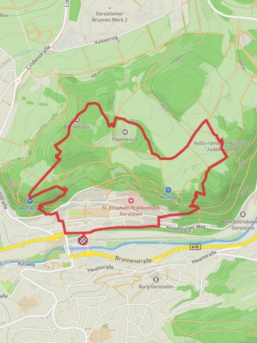
#### Munterley Continuing along the trail, you'll reach Munterley, a prominent rock formation that offers stunning views of the Eifel region. This is a great spot to take a break and soak in the scenery. The rock formations here are a testament to the area's volcanic past, and you'll find plenty of opportunities for photography.
### Historical Significance The Eifel region is rich in history, and this trail is no exception. As you hike, you'll come across remnants of ancient volcanic activity that shaped the landscape millions of years ago. The area is also dotted with historical landmarks, including old castles and ruins that date back to medieval times. Be sure to take some time to explore these sites and appreciate the historical context they provide.
### Navigation and Safety For navigation, it's highly recommended to use the HiiKER app, which provides detailed maps and real-time updates. The trail is well-marked, but having a reliable navigation tool will ensure you stay on track. The terrain can be uneven in places, so sturdy hiking boots are a must. Also, bring plenty of water and snacks, as there are limited facilities along the trail.
### Flora and Fauna The Eifel region is known for its rich biodiversity. As you hike, you'll pass through mixed forests of beech, oak, and pine. In the spring and summer, the trail is adorned with wildflowers, adding a splash of color to the landscape. Wildlife enthusiasts will enjoy spotting deer, foxes, and a variety of bird species, including woodpeckers and owls.
### Final Stretch As you loop back towards the trailhead, the descent offers a gentle relief from the earlier climbs. The final stretch takes you through serene woodlands and open meadows, providing a peaceful end to your hike. The trail concludes back at the starting point near Vulkaneifel, where you can reflect on the diverse landscapes and historical landmarks you've encountered.
This trail offers a perfect blend of natural beauty, historical significance, and moderate physical challenge, making it a must-visit for any hiking enthusiast.
Reviews
User comments, reviews and discussions about the Auberg and Munterley via Eifelsteig and Vulkanweg, Germany.
4.0
average rating out of 5
5 rating(s)


