5.9 km
~1 hrs 30 min
190 m
“Explore the scenic Frillensee Loop's diverse landscapes and moderate challenges near Traunstein, Germany.”
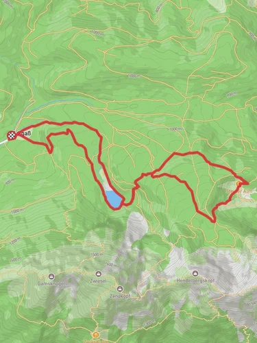
Starting near the charming town of Traunstein, Germany, the Frillensee Loop via Frillensee Runde is a delightful 6 km (approximately 3.7 miles) loop trail with an elevation gain of around 100 meters (328 feet). This trail is rated as medium difficulty, making it suitable for moderately experienced hikers.
### Getting There To reach the trailhead, you can either drive or use public transport. If you're driving, head towards Traunstein and follow signs to the Frillensee area. For those using public transport, take a train to Traunstein station. From there, you can catch a local bus or taxi to the trailhead near Frillensee.
### Trail Overview The trail begins near the picturesque Frillensee, a small lake nestled in the Bavarian Alps. The loop takes you through dense forests, open meadows, and along the serene lakeshore, offering a variety of landscapes to enjoy.
### Key Landmarks and Points of Interest - Frillensee: The trail starts and ends at this beautiful alpine lake. It's a great spot for a picnic or a quick swim in the summer months. - Forested Sections: As you hike through the dense forest, keep an eye out for local wildlife such as deer, foxes, and a variety of bird species. The forest is also home to several types of mushrooms and wildflowers, especially in the spring and summer. - Open Meadows: About halfway through the loop, you'll come across open meadows that offer stunning views of the surrounding mountains. This is a great spot to take a break and soak in the scenery. - Historical Significance: The region around Traunstein has a rich history dating back to the Roman era. While the trail itself doesn't have specific historical landmarks, the area is steeped in cultural heritage. Traunstein is known for its traditional Bavarian architecture and annual festivals.
### Navigation and Safety The trail is well-marked, but it's always a good idea to have a reliable navigation tool. HiiKER is an excellent app for this purpose, providing detailed maps and real-time tracking to ensure you stay on course.
### Elevation and Terrain The elevation gain is moderate, with a total ascent of around 100 meters (328 feet). The trail features a mix of flat sections and gentle inclines, making it accessible for most hikers. However, be prepared for some uneven terrain, especially in the forested areas.
### Flora and Fauna The trail offers a rich tapestry of flora and fauna. In the spring and summer, you'll find a variety of wildflowers, including edelweiss and alpine roses. The forested sections are home to towering fir and spruce trees. Wildlife is abundant, so keep your eyes peeled for deer, foxes, and various bird species.
### Practical Tips - Footwear: Sturdy hiking boots are recommended due to the uneven terrain. - Weather: Check the weather forecast before you go. The trail can be slippery after rain, and conditions can change rapidly in the mountains. - Supplies: Bring enough water and snacks, as there are no facilities along the trail. - Leave No Trace: Ensure you pack out all your trash and respect the natural environment.
This trail offers a perfect blend of natural beauty, moderate challenge, and a touch of historical intrigue, making it a rewarding experience for any hiker.
Reviews
User comments, reviews and discussions about the Frillensee Loop via Frillensee Runde, Germany.
5.0
average rating out of 5
7 rating(s)


