8.8 km
~2 hrs 1 min
162 m
“Explore a 9 km scenic loop through lush forests, historical landmarks, and serene meadows near Herrenstrunden.”
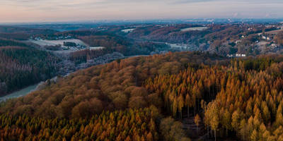
Starting near the picturesque Rheinisch-Bergischer Kreis in Germany, this 9 km (approximately 5.6 miles) loop trail offers a delightful mix of natural beauty and historical intrigue. With an elevation gain of around 100 meters (328 feet), the trail is rated as medium difficulty, making it suitable for moderately experienced hikers.
### Getting There To reach the trailhead, you can either drive or use public transport. If driving, set your GPS to Herrenstrunden, a small village near Bergisch Gladbach. For those using public transport, take a train to Bergisch Gladbach station and then a bus to Herrenstrunden. The bus stop is conveniently located near the trailhead, making it easy to start your hike.
### Trail Overview The trail begins near the Herrenstrunden village, a charming area known for its historical significance and natural beauty. As you start your hike, you'll follow the Herrenstrunden Rundweg, a well-marked path that takes you through lush forests and serene meadows. The initial part of the trail is relatively flat, allowing you to ease into the hike.
### Significant Landmarks Around the 2 km (1.2 miles) mark, you'll come across the Herrenstrunder Teich, a beautiful pond that serves as a perfect spot for a short break. The pond is surrounded by dense forest, offering a tranquil setting to enjoy the natural surroundings. Keep an eye out for local wildlife, including various bird species and small mammals.
### Historical Significance As you continue, you'll intersect with the Geopfad Berg, a geological path that offers fascinating insights into the region's geological history. This area is rich in mineral deposits, and you'll find several informational plaques explaining the geological formations and their historical significance. The trail also passes by remnants of old mining operations, providing a glimpse into the area's industrial past.
### Elevation and Terrain The trail gradually ascends as you approach the 5 km (3.1 miles) mark, gaining around 50 meters (164 feet) in elevation. The terrain becomes slightly more challenging here, with a mix of rocky paths and forest trails. Good hiking boots are recommended to navigate this section comfortably.
### Flora and Fauna The trail is abundant with diverse flora and fauna. Depending on the season, you might see wildflowers, ferns, and various types of trees, including oak and beech. Wildlife enthusiasts will appreciate the chance to spot deer, foxes, and a variety of bird species.
### Navigation For navigation, it's advisable to use the HiiKER app, which provides detailed maps and real-time updates. The trail is well-marked, but having a reliable navigation tool can enhance your hiking experience and ensure you stay on the right path.
### Final Stretch As you near the end of the loop, the trail descends gently back towards Herrenstrunden. The final 2 km (1.2 miles) offer a leisurely walk through open fields and along a small stream, providing a relaxing end to your hike.
This trail offers a perfect blend of natural beauty, historical significance, and moderate physical challenge, making it a rewarding experience for any hiker.
Reviews
User comments, reviews and discussions about the Herrenstrunder Teich via Herrenstrunden Rundweg and Geopfad Berg, Germany.
0.0
average rating out of 5
0 rating(s)


