10.3 km
~2 hrs 19 min
164 m
“Explore Much Rundweg Volldreieck: a 10 km scenic loop blending natural beauty, history, and moderate hiking challenge.”
Starting near the picturesque Rhein-Sieg-Kreis in Germany, this 10 km (approximately 6.2 miles) loop trail offers a delightful mix of natural beauty and moderate challenge, making it an excellent choice for hikers of varying skill levels. With an elevation gain of around 100 meters (328 feet), the Much Rundweg Volldreieck provides a manageable ascent that rewards you with stunning views and a sense of accomplishment.
### Getting There To reach the trailhead, you can drive or use public transportation. If driving, set your GPS to Much, a charming town in the Rhein-Sieg-Kreis district. There are several parking options available near the town center. For those relying on public transport, take a train to the nearest major station, Siegburg/Bonn, and then a bus to Much. The bus services are frequent and reliable, making it easy to access the trailhead.
### Trail Navigation For navigation, the HiiKER app is highly recommended. It provides detailed maps and real-time updates, ensuring you stay on track throughout your hike.
### Trail Highlights The trail begins near the town center of Much, where you can find amenities such as cafes and shops to stock up on supplies. As you set off, the initial part of the trail meanders through lush meadows and rolling hills, offering a gentle introduction to the hike.
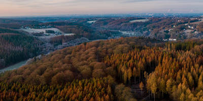
#### Nature and Wildlife Around the 2 km (1.2 miles) mark, you'll enter a dense forest area. This section is particularly enchanting, with towering trees and a rich undergrowth that is home to various species of birds and small mammals. Keep an eye out for deer, which are often spotted in the early morning or late afternoon.
#### Historical Significance At approximately 4 km (2.5 miles), you'll come across the ruins of an old mill, a testament to the region's historical reliance on agriculture and milling. This spot is perfect for a short break and some exploration. The mill dates back to the 18th century and offers a glimpse into the past life of the local community.
### Mid-Trail Features As you continue, the trail begins a gentle ascent, reaching its highest point around the 6 km (3.7 miles) mark. Here, you'll be rewarded with panoramic views of the surrounding countryside. On clear days, you can see as far as the Siebengebirge mountain range. This is an ideal spot for a picnic, so consider packing a light meal to enjoy while taking in the scenery.
### Final Stretch The descent begins around the 8 km (5 miles) point, leading you back through a mix of open fields and wooded areas. This section is relatively easy, allowing you to relax and enjoy the final leg of your journey. As you approach the end of the trail, you'll pass by several traditional German houses, offering a quaint and picturesque conclusion to your hike.
### Practical Tips - Wear sturdy hiking boots, as some sections of the trail can be uneven. - Bring plenty of water, especially during the warmer months. - Check the weather forecast before you set out, as conditions can change rapidly. - Use the HiiKER app for navigation to ensure you stay on the correct path.
This trail offers a perfect blend of natural beauty, moderate physical challenge, and historical intrigue, making it a must-visit for any hiking enthusiast.
Reviews
User comments, reviews and discussions about the Much Rundweg Volldreieck, Germany.
0.0
average rating out of 5
0 rating(s)


