12.3 km
~2 hrs 49 min
219 m
“The Much Rundweg Loop in Germany offers scenic trails, historical ruins, and diverse landscapes for moderate hikers.”
Starting near Rhein-Sieg-Kreis, Germany, the Much Rundweg Loop is a scenic 12 km (7.5 miles) trail with an elevation gain of approximately 200 meters (656 feet). This loop trail is rated as medium difficulty, making it suitable for moderately experienced hikers.
### Getting There To reach the trailhead, you can either drive or use public transport. If driving, set your GPS to Much, a charming town in the Rhein-Sieg-Kreis district. There are several parking options available in the town center. For those using public transport, take a train to Siegburg/Bonn station and then a bus to Much. The bus ride offers a picturesque view of the German countryside, setting the tone for your hike.
### Trail Navigation For navigation, it's highly recommended to use the HiiKER app, which provides detailed maps and real-time updates. The trail is well-marked, but having a reliable navigation tool ensures you stay on track.
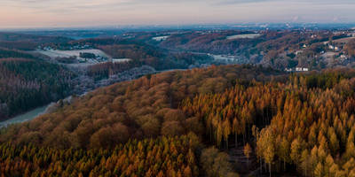
### Trail Highlights The Much Rundweg Loop offers a variety of landscapes, from dense forests to open meadows. Starting from the trailhead, the first 2 km (1.2 miles) take you through a serene forest area. The path is well-trodden but can be muddy after rain, so waterproof hiking boots are advisable.
### Historical Significance Around the 4 km (2.5 miles) mark, you'll come across the ruins of an old mill, a relic from the 18th century. This site offers a glimpse into the region's industrial past and is a great spot for a short break. Information boards provide historical context, making it a mini-history lesson amidst your hike.
### Flora and Fauna As you continue, the trail opens up into a meadow around the 6 km (3.7 miles) point. This area is rich in wildflowers during the spring and summer months. Keep an eye out for local wildlife, including deer and various bird species. The meadow also offers panoramic views of the surrounding hills, perfect for photography enthusiasts.
### Midpoint Rest Area At approximately 8 km (5 miles), you'll find a designated rest area equipped with benches and a small shelter. This is an ideal spot to refuel with some snacks and water. The elevation gain is gradual but noticeable, so taking a break here can help you recharge for the remaining distance.
### Final Stretch The last 4 km (2.5 miles) of the trail take you through a mix of forest and farmland. The path is relatively flat, making for an easier finish. As you approach the end of the loop, you'll pass by a small pond, often frequented by ducks and other waterfowl. This tranquil setting provides a peaceful conclusion to your hike.
### Practical Tips - Wear sturdy hiking boots, especially if the weather has been wet. - Carry enough water and snacks, as there are limited facilities along the trail. - Use the HiiKER app for navigation to ensure you stay on the correct path. - Check the weather forecast before heading out, as conditions can change rapidly.
The Much Rundweg Loop offers a balanced mix of natural beauty, historical landmarks, and moderate physical challenge, making it a rewarding experience for hikers.
Reviews
User comments, reviews and discussions about the Much Rundweg Loop, Germany.
0.0
average rating out of 5
0 rating(s)


