7.8 km
~2 hrs 29 min
566 m
“Experience the stunning natural beauty and rich history of Rhein-Neckar-Kreis on this 8 km scenic hike.”
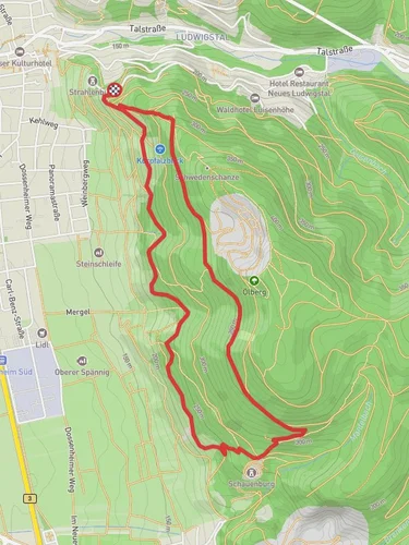
Starting near the picturesque region of Rhein-Neckar-Kreis in Germany, this 8 km (approximately 5 miles) loop trail offers a delightful mix of natural beauty and historical intrigue. With an elevation gain of around 500 meters (about 1,640 feet), it is rated as a medium difficulty hike, making it suitable for moderately experienced hikers.
### Getting There To reach the trailhead, you can either drive or use public transport. If driving, set your GPS to the nearest known address: the village of Wilhelmsfeld. There is ample parking available near the trailhead. For those using public transport, take a train to Heidelberg and then a bus to Wilhelmsfeld. The bus stop is conveniently located near the start of the trail.
### Trail Navigation For navigation, it is highly recommended to use the HiiKER app, which provides detailed maps and real-time updates to ensure you stay on track.
### The Hike The trail begins with a gentle ascent through dense forests, offering a serene environment filled with the sounds of chirping birds and rustling leaves. After about 1 km (0.6 miles), you will encounter the first significant landmark: the historic Wilhelmsfeld Tower. This tower offers panoramic views of the surrounding countryside and is a great spot for a short break.
Continuing on, the trail becomes steeper as you approach the 3 km (1.9 miles) mark. Here, you will gain approximately 200 meters (656 feet) in elevation. The effort is well worth it, as you will be rewarded with stunning vistas of the Odenwald forest and the Neckar River valley.
### Flora and Fauna The trail is rich in biodiversity. Keep an eye out for native wildlife such as deer, foxes, and a variety of bird species. The forest is predominantly composed of beech and oak trees, which provide ample shade during the warmer months. In spring and early summer, the forest floor is carpeted with wildflowers, adding a splash of color to your hike.
### Historical Significance The region has a rich history dating back to Roman times. As you hike, you will come across several information boards detailing the historical significance of the area, including ancient Roman roads and medieval trade routes. These boards are located at approximately 4 km (2.5 miles) and 6 km (3.7 miles) into the hike.
### Final Stretch The last 2 km (1.2 miles) of the trail are relatively flat and take you through open meadows and small streams. This section is perfect for cooling down and enjoying the tranquil scenery. As you loop back towards Wilhelmsfeld, you will pass by a charming old mill, which has been converted into a small museum showcasing the region's agricultural history.
### Practical Tips - Wear sturdy hiking boots, as the trail can be rocky and uneven in places. - Bring plenty of water and snacks, especially if you plan to take breaks at the various landmarks. - Check the weather forecast before you go, as the trail can be slippery after rain. - Use the HiiKER app for real-time navigation and updates.
This trail offers a perfect blend of natural beauty, historical landmarks, and moderate physical challenge, making it a rewarding experience for any hiker.
Reviews
User comments, reviews and discussions about the Rundwanderweg Kehrrang, Germany.
0.0
average rating out of 5
0 rating(s)


