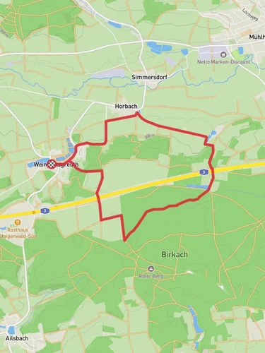
9.8 km
~2 hrs 11 min
144 m
“Experience a captivating 10 km loop near Weingartsgreuth, blending scenic landscapes and historical landmarks.”
Starting near the charming village of Weingartsgreuth in the Erlangen-Höchstadt district of Germany, this 10 km (6.2 miles) loop trail offers a delightful mix of natural beauty and historical intrigue. With an elevation gain of approximately 100 meters (328 feet), the trail is rated as medium difficulty, making it accessible for most hikers with a moderate level of fitness.
### Getting There To reach the trailhead, you can drive or use public transport. If driving, set your GPS to Weingartsgreuth, Erlangen-Höchstadt, Germany. There is ample parking available near the village center. For those using public transport, take a train to Erlangen and then a local bus to Weingartsgreuth. The bus stop is conveniently located near the trailhead.
### Trail Navigation For navigation, it is highly recommended to use the HiiKER app, which provides detailed maps and real-time updates to ensure you stay on track.
### Trail Highlights The trail begins in the heart of Weingartsgreuth, a village known for its picturesque half-timbered houses and serene countryside. As you set off, you'll quickly find yourself immersed in a landscape of rolling hills and lush forests.
#### First Section: Weingartsgreuth to the Forest The initial 2 km (1.2 miles) of the trail takes you through open fields and meadows. This section is relatively flat, making it a good warm-up. Keep an eye out for local wildlife such as deer and various bird species that frequent the area.
#### Entering the Forest Around the 2 km mark, the trail enters a dense forest. The canopy provides a welcome shade, especially during the warmer months. The forest path is well-marked but can be uneven in places, so sturdy hiking boots are recommended. This section also includes a gentle ascent, contributing to the overall elevation gain.
#### Historical Landmarks Approximately 4 km (2.5 miles) into the hike, you'll come across the ruins of an old mill, a testament to the region's historical reliance on agriculture and milling. Take a moment to explore the ruins and imagine the bustling activity that once took place here.
#### Midpoint: Scenic Overlook At around the 5 km (3.1 miles) mark, you'll reach a scenic overlook that offers panoramic views of the surrounding countryside. This is an excellent spot for a break and some photographs. The elevation here is about 100 meters (328 feet) above the starting point, providing a rewarding sense of accomplishment.
#### Return Loop The trail then loops back towards Weingartsgreuth, descending gradually through more forested areas and open fields. This section is less strenuous, allowing you to enjoy the natural beauty at a leisurely pace.
### Flora and Fauna The trail is rich in biodiversity. In spring and summer, the meadows are adorned with wildflowers, while the forest areas are home to a variety of trees including oak, beech, and pine. Wildlife sightings are common, so keep your camera ready.
### Final Stretch As you approach the final 2 km (1.2 miles) of the loop, the trail opens up again into agricultural land. You'll pass by several small farms and vineyards, offering a glimpse into the local way of life. The trail concludes back in Weingartsgreuth, where you can relax and perhaps enjoy a meal at a local eatery.
This trail offers a perfect blend of natural beauty, moderate physical challenge, and historical interest, making it a rewarding experience for any hiker.
Reviews
User comments, reviews and discussions about the Weingartsgreuth W8, Germany.
5.0
average rating out of 5
1 rating(s)


