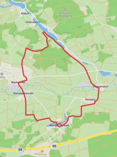
7.2 km
~1 hrs 39 min
128 m
“Discover the charming Weingartsgreuth Loop: a 7 km hike through scenic landscapes and historical ruins.”
Starting near the charming village of Weingartsgreuth in the Erlangen-Höchstadt district of Germany, this 7 km (approximately 4.3 miles) loop trail offers a delightful mix of natural beauty and historical intrigue. The trailhead is conveniently accessible by car, with parking available near the village center. For those using public transport, the nearest significant landmark is the Erlangen train station, from where you can take a local bus to Weingartsgreuth.
### Trail Overview
The Weingartsgreuth Loop is a moderately challenging hike with an elevation gain of around 100 meters (328 feet). The trail meanders through a picturesque landscape of rolling hills, dense forests, and open meadows, providing a diverse hiking experience. The loop nature of the trail means you'll end up back where you started, making logistics simpler.
### Key Landmarks and Points of Interest
#### Weingartsgreuth Village Starting your hike in Weingartsgreuth, you'll immediately notice the quaint charm of this small village. The traditional Bavarian architecture and the serene atmosphere set the tone for the hike ahead.
#### Forested Sections About 1.5 km (0.9 miles) into the hike, you'll enter a dense forest. This section is particularly beautiful in the autumn when the leaves turn vibrant shades of red and gold. Keep an eye out for local wildlife such as deer and various bird species. The forest canopy provides ample shade, making this part of the trail cooler and more comfortable, especially during the summer months.
#### Open Meadows Around the 3 km (1.9 miles) mark, the trail opens up into expansive meadows. These areas offer stunning panoramic views of the surrounding countryside. It's a great spot to take a break, have a snack, and enjoy the scenery. The meadows are also home to a variety of wildflowers, particularly in the spring and early summer.
### Historical Significance
#### Medieval Ruins Approximately 4.5 km (2.8 miles) into the hike, you'll come across the ruins of a medieval watchtower. This site offers a glimpse into the region's historical significance as a strategic point during medieval times. The ruins are a great spot for history enthusiasts and provide a unique backdrop for photos.
### Navigation and Safety
Given the moderate difficulty of the trail, it's advisable to use a reliable navigation tool like HiiKER to keep track of your progress and ensure you stay on the correct path. The trail is well-marked, but having a digital map can be particularly useful in the forested sections where the path can sometimes be less obvious.
### Flora and Fauna
The Weingartsgreuth Loop is rich in biodiversity. In the forested areas, you'll find a variety of tree species including oak, beech, and pine. The meadows are home to numerous wildflowers and grasses, attracting butterflies and bees. Birdwatchers will also find plenty to enjoy, with species such as woodpeckers, finches, and even the occasional hawk.
### Getting There
For those driving, Weingartsgreuth is easily accessible from the A3 motorway. Parking is available near the village center. If you're using public transport, take a train to Erlangen station and then a local bus to Weingartsgreuth. The bus ride offers a scenic view of the Bavarian countryside, adding to the overall experience of your hiking adventure.
This trail offers a perfect blend of natural beauty, historical landmarks, and moderate physical challenge, making it an excellent choice for a day hike.
Reviews
User comments, reviews and discussions about the Weingartsgreuth Loop, Germany.
0.0
average rating out of 5
0 rating(s)


