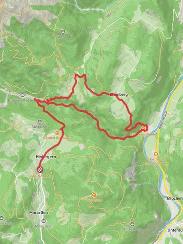
7.5 km
~2 hrs 29 min
593 m
“Explore Almbachklamm's 8 km loop for stunning views, historical sites, diverse wildlife, and moderate challenges.”
Starting your adventure near Berchtesgadener Land, Germany, the Theresienklause via Almbachklamm trail offers a captivating 8 km (5 miles) loop with an elevation gain of approximately 500 meters (1,640 feet). This medium-difficulty hike is perfect for those looking to explore the natural beauty and historical significance of the region.
### Getting There To reach the trailhead, you can drive or use public transport. If driving, set your GPS to Almbachklamm, 83487 Marktschellenberg, Germany. For public transport, take a train to Berchtesgaden Hauptbahnhof and then a bus (Bus 840) to the Almbachklamm stop. From there, it's a short walk to the trailhead.
### Trail Overview The trail begins near the entrance to the Almbachklamm gorge, a stunning natural feature carved by the Almbach river. As you start your hike, you'll be greeted by the sound of rushing water and the sight of steep, rocky walls. The first section of the trail takes you through the gorge, where you'll cross several bridges and pass by numerous waterfalls. This part of the hike is relatively flat, making it a good warm-up for the more challenging sections ahead.
### Historical Significance About 2 km (1.2 miles) into the hike, you'll come across the Theresienklause, a historic dam built in the 19th century. This structure was originally used to control the flow of water for timber rafting, a crucial industry in the region at the time. The dam is named after Queen Therese of Bavaria and offers a fascinating glimpse into the area's industrial past.
### Climbing Higher After exploring the Theresienklause, the trail begins to ascend more steeply. You'll gain about 300 meters (984 feet) in elevation over the next 3 km (1.9 miles). This section of the trail is more strenuous, with several switchbacks and rocky terrain. However, the effort is well worth it, as you'll be rewarded with panoramic views of the surrounding mountains and valleys.
### Flora and Fauna As you climb, keep an eye out for the diverse flora and fauna that inhabit the area. The trail passes through mixed forests of beech, fir, and spruce trees. In the spring and summer, the forest floor is carpeted with wildflowers, including orchids and gentians. Wildlife is abundant, and you may spot deer, chamois, and a variety of bird species, including the elusive golden eagle.
### Reaching the Summit At around the 5 km (3.1 miles) mark, you'll reach the highest point of the trail. Take a moment to rest and enjoy the breathtaking views before beginning your descent. The trail loops back down through a series of meadows and forests, offering a more gradual decline.
### Final Stretch The last 3 km (1.9 miles) of the trail are relatively easy, taking you through picturesque alpine meadows and past traditional Bavarian farmhouses. You'll eventually rejoin the Almbachklamm gorge, where you can enjoy the soothing sounds of the river as you make your way back to the trailhead.
### Navigation For navigation, it's highly recommended to use the HiiKER app, which provides detailed maps and real-time updates to ensure you stay on track.
This hike offers a perfect blend of natural beauty, historical intrigue, and physical challenge, making it a must-do for any avid hiker visiting the Berchtesgadener Land region.
Reviews
User comments, reviews and discussions about the Theresienklause via Almbachklamm, Germany.
4.0
average rating out of 5
5 rating(s)


