4.1 km
~1 hrs 35 min
461 m
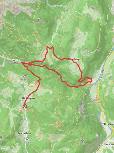
“Explore Almbachklamm's stunning gorge, forest paths, and historic sites on this 4 km, medium-difficulty loop.”
Starting near Berchtesgadener Land in Germany, the Almbachklamm and Hammerstielweg Loop is a captivating 4 km (2.5 miles) trail with an elevation gain of approximately 400 meters (1,312 feet). This loop trail is rated medium in difficulty, making it suitable for moderately experienced hikers.
### Getting There To reach the trailhead, you can drive or use public transport. If driving, set your GPS to Kugelmühle, 83487 Marktschellenberg, Germany. For public transport, take a train to Berchtesgaden Hauptbahnhof and then a bus to the Kugelmühle stop. From there, it's a short walk to the trailhead.
### Trail Highlights The trail begins at the historic Kugelmühle, one of the last marble ball mills in Germany. This site offers a glimpse into the region's industrial past, where marble balls were once crafted for various uses.
### Almbachklamm Gorge As you start the hike, you'll enter the Almbachklamm Gorge, a stunning natural feature carved by the Almbach River. The gorge is adorned with wooden bridges and walkways, providing safe passage through this rugged terrain. The sound of cascading waterfalls accompanies you as you navigate this section, which spans approximately 1.5 km (0.9 miles) with an elevation gain of about 150 meters (492 feet).
### Flora and Fauna The gorge is rich in biodiversity. Look out for various species of ferns, mosses, and wildflowers clinging to the damp rock faces. Birdwatchers might spot dippers and wagtails flitting along the river, while the more observant might catch a glimpse of a chamois on the higher cliffs.
### Hammerstielweg Path After exiting the gorge, the trail transitions into the Hammerstielweg path. This section is less rugged but offers its own set of challenges with a steady incline. The path meanders through dense forests of beech and fir, providing ample shade and a serene atmosphere. This part of the trail covers around 2.5 km (1.6 miles) with an elevation gain of about 250 meters (820 feet).
### Panoramic Views As you ascend, the forest opens up to offer panoramic views of the Berchtesgaden Alps. Key peaks to look out for include the Watzmann and the Hochkalter. These vistas are perfect for a rest stop and some photography.
### Historical Significance The region around Berchtesgadener Land is steeped in history. During your hike, you might come across remnants of old smuggling routes used during World War II. The area was also a favorite retreat for Bavarian royalty, adding a layer of historical intrigue to your journey.
### Navigation For navigation, it's highly recommended to use the HiiKER app, which provides detailed maps and real-time updates to ensure you stay on track.
### Wildlife Keep an eye out for local wildlife such as red deer, foxes, and various bird species. The diverse habitats along the trail support a wide range of fauna, making it a rewarding experience for nature enthusiasts.
### Return to Trailhead The loop eventually brings you back to the starting point at Kugelmühle. Here, you can take a moment to relax and perhaps visit the nearby café for some refreshments before heading back.
This trail offers a blend of natural beauty, historical significance, and moderate physical challenge, making it a must-visit for hikers in the region.
Reviews
User comments, reviews and discussions about the Almbachklamm and Hammerstielweg Loop, Germany.
4.0
average rating out of 5
1 rating(s)


