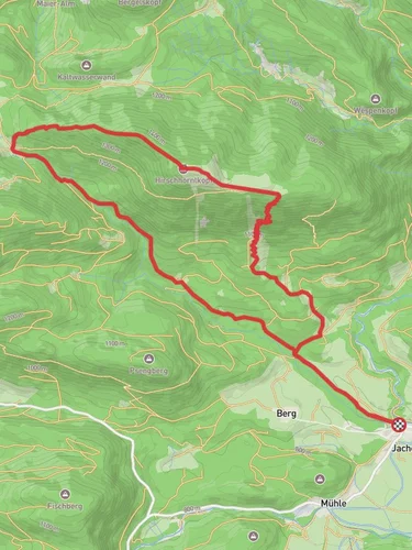
13.2 km
~4 hrs 11 min
933 m
“Embark on a scenic 13 km hike with stunning alpine views and rich biodiversity near Bad Tölz-Wolfratshausen.”
Starting your adventure near Bad Tölz-Wolfratshausen, Germany, the Latschenkopf and Langenecksattel Loop is a captivating 13 km (8 miles) journey with an elevation gain of approximately 900 meters (2,950 feet). This loop trail is rated medium in difficulty, making it suitable for moderately experienced hikers.
### Getting There To reach the trailhead, you can drive or use public transport. If driving, head towards Bad Tölz-Wolfratshausen and look for parking options near the trailhead. For those using public transport, take a train to Bad Tölz station. From there, local buses or taxis can take you closer to the starting point.
### Trail Overview The trail begins with a gentle ascent through lush forests, offering a serene start to your hike. As you progress, the path becomes steeper, leading you to the first significant landmark, the Latschenkopf peak. This section covers roughly 5 km (3.1 miles) and gains about 500 meters (1,640 feet) in elevation. The views from Latschenkopf are breathtaking, providing panoramic vistas of the Bavarian Alps.
### Flora and Fauna The trail is rich in biodiversity. Keep an eye out for native wildlife such as deer, foxes, and various bird species. The flora is equally impressive, with dense forests of spruce and fir, interspersed with alpine meadows that bloom with wildflowers in the spring and summer months.
### Historical Significance The region around Bad Tölz-Wolfratshausen has a rich history dating back to medieval times. The town of Bad Tölz itself is known for its historic architecture and traditional Bavarian culture. As you hike, you may come across old shepherd huts and remnants of ancient trade routes that once connected the region.
### Langenecksattel After enjoying the views from Latschenkopf, the trail descends slightly before ascending again towards Langenecksattel. This section is about 4 km (2.5 miles) long and involves an elevation gain of approximately 300 meters (985 feet). The saddle offers another excellent viewpoint, perfect for a rest and some photography.
### Navigation For navigation, it is highly recommended to use HiiKER, which provides detailed maps and real-time updates. The trail is well-marked, but having a reliable navigation tool ensures you stay on track.
### Final Stretch The final part of the loop takes you back down through a series of switchbacks, leading you through more forested areas and eventually back to the trailhead. This descent covers the remaining 4 km (2.5 miles) and is relatively gentle, allowing you to enjoy the natural beauty of the area as you wind down your hike.
### Practical Tips - Wear sturdy hiking boots, as the trail can be rocky and uneven in places. - Bring plenty of water and snacks, especially during the warmer months. - Check the weather forecast before you go, as conditions can change rapidly in the mountains. - A hiking pole can be helpful for the steeper sections of the trail.
This loop offers a perfect blend of natural beauty, moderate challenge, and historical intrigue, making it a must-do for any hiking enthusiast visiting the Bavarian Alps.

Reviews
User comments, reviews and discussions about the Latschenkopf and Langenecksattel Loop, Germany.
0.0
average rating out of 5
0 rating(s)