12.0 km
~3 hrs 3 min
389 m
“Explore a 12 km trail from Greenhead, blending lush landscapes, Roman ruins, and medieval castles.”
Starting near the charming village of Greenhead in Northumberland, England, this 12 km (approximately 7.5 miles) point-to-point trail offers a delightful mix of natural beauty and historical intrigue. With an elevation gain of around 300 meters (approximately 984 feet), the trail is rated as medium difficulty, making it accessible for most hikers with a moderate level of fitness.
### Getting There To reach the trailhead, you can either drive or use public transport. If driving, head towards Greenhead, which is easily accessible via the A69 road. For those using public transport, Greenhead is served by local bus routes, and the nearest train station is Haltwhistle, about 3 miles (4.8 km) away. From Haltwhistle, you can take a taxi or a local bus to Greenhead.
### Trail Highlights and Landmarks As you set off from Greenhead, you'll immediately be immersed in the lush, rolling landscapes characteristic of Northumberland. The trail initially takes you through verdant fields and pastures, where you might spot local wildlife such as red squirrels, roe deer, and a variety of bird species.
#### Hadrian's Wall One of the most significant landmarks along this trail is Hadrian's Wall, a UNESCO World Heritage Site. Approximately 2 km (1.2 miles) into your hike, you'll encounter this ancient Roman fortification. Built in AD 122, the wall stretches across Northern England and offers a fascinating glimpse into the region's Roman past. Take some time to explore the well-preserved sections and imagine the lives of the Roman soldiers who once guarded this frontier.
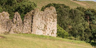
#### Thirlwall Castle Continuing along the trail, about 4 km (2.5 miles) from the start, you'll come across Thirlwall Castle. This medieval ruin, perched on a hill, offers panoramic views of the surrounding countryside. The castle dates back to the 12th century and was built using stones from Hadrian's Wall, adding another layer of historical significance to your journey.
### Nature and Scenery As you progress, the trail meanders through a mix of woodland and open moorland. The diverse terrain provides a habitat for a variety of flora and fauna. In spring and summer, the wildflowers are in full bloom, adding vibrant splashes of color to the landscape. Keep an eye out for heather and gorse, which are particularly striking during these seasons.
#### Crag Lough Around the 8 km (5 miles) mark, you'll reach Crag Lough, a picturesque lake nestled among rocky crags. This is an excellent spot for a rest and some photography. The lake is home to various waterfowl, and the surrounding cliffs are popular with rock climbers.
### Final Stretch to Once Brewed The final section of the trail takes you through more open moorland before descending towards the village of Once Brewed. This part of the hike offers sweeping views of the Northumberland National Park. The descent is relatively gentle, but be mindful of your footing, especially if the ground is wet.
### Navigation and Safety For navigation, it's highly recommended to use the HiiKER app, which provides detailed maps and real-time tracking to ensure you stay on course. The trail is generally well-marked, but having a reliable navigation tool will enhance your hiking experience and provide peace of mind.
### Historical Significance The entire region is steeped in history, from the Roman era to medieval times. Walking this trail is like stepping back in time, offering a unique blend of natural beauty and historical landmarks. Whether you're a history buff or simply enjoy a good hike, this trail has something for everyone.
Prepare adequately with water, snacks, and appropriate clothing, as the weather in Northumberland can be unpredictable. Enjoy your hike through this captivating part of England, where every step brings you closer to the past and the stunning natural world.
Reviews
User comments, reviews and discussions about the Greenhead to Once Brewed Walk, England.
0.0
average rating out of 5
0 rating(s)


