Download
3D Flyover
Add to list
More
38.7 km
~2 days
1444 m
Multi-Day
“Embark on Oregon's Steens Mountain Gorge Loop for a stunning, diverse high-desert hiking adventure.”
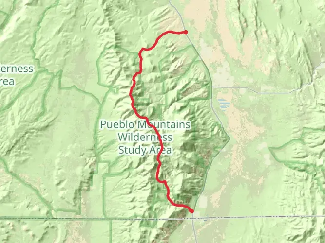
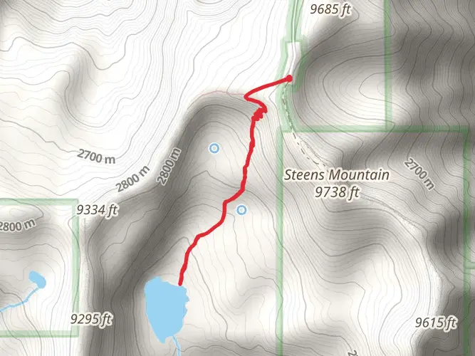
The Steens Mountain Gorge Loop is a challenging and rewarding hike located near Harney County, Oregon. Spanning approximately 39 kilometers (about 24 miles), with an elevation gain of roughly 1400 meters (around 4600 feet), this loop trail offers a diverse and scenic experience through one of Oregon's natural treasures.
Getting to the Trailhead
To reach the trailhead, you can drive to the South Steens Campground, which is the closest landmark to the starting point. The campground is accessible by car via the Steens Mountain Loop Road, a well-maintained gravel road suitable for most vehicles during the dry season. Public transportation options are limited in this remote area, so driving is the most feasible way to get to the trail.
Navigating the Trail
Once at the trailhead, hikers can use the HiiKER app to navigate the loop. The trail is well-marked, but due to its remote nature and challenging terrain, it's essential to have a reliable navigation tool.
Landmarks and Scenery
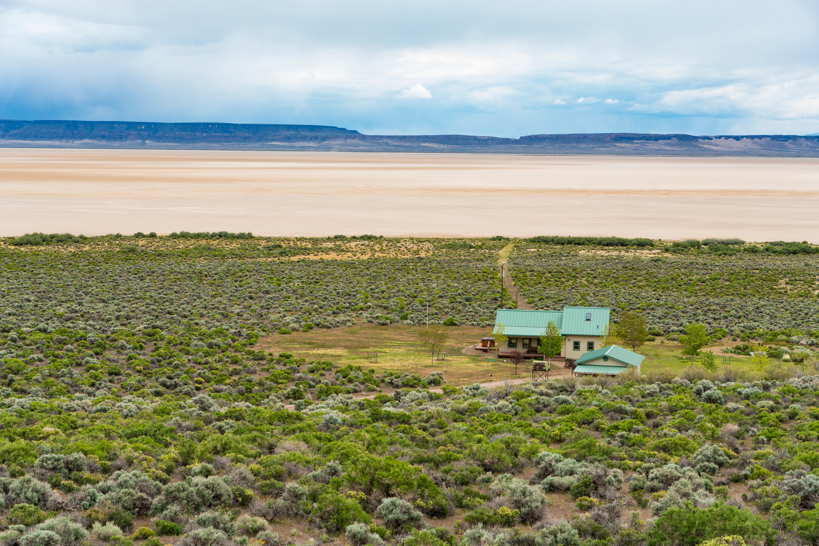
As you embark on the Steens Mountain Gorge Loop, you'll traverse a variety of landscapes, including high desert, rugged gorges, and alpine meadows. The trail offers stunning views of the surrounding valleys and peaks, with the vast expanse of the Alvord Desert visible to the east.
Wildlife and Flora
The area is home to a rich array of wildlife, including pronghorn antelope, bighorn sheep, and wild horses. Birdwatchers may also spot golden eagles, hawks, and the elusive greater sage-grouse. The flora along the trail is equally diverse, with sagebrush, juniper trees, and wildflowers like Indian paintbrush and lupine adding color to the landscape.
Historical Significance
Steens Mountain has a rich history, with evidence of Native American habitation dating back thousands of years. The region was also part of the early pioneer trails, and hikers may come across remnants of these early settlers' presence.
Trail Challenges
The loop is rated as difficult due to its steep inclines, high elevation, and the need for self-sufficiency. Hikers should be prepared for sudden weather changes and carry enough water, as sources along the trail are scarce.
Preparation and Safety
Before setting out, ensure you have the proper gear, including sturdy hiking boots, weather-appropriate clothing, and a first-aid kit. It's also wise to inform someone of your hiking plans and expected return time.
By preparing adequately and respecting the natural environment, hikers can enjoy the beauty and challenge of the Steens Mountain Gorge Loop, a true gem in Oregon's wild landscape.

What to expect?
Activity types
Frequently asked questions
How long is the Steens Mountain Gorge Loop and how hard is it?
The Steens Mountain Gorge Loop is 38.72 kilometers long, or about 24.1 miles, with 1,444 meters of elevation gain, roughly 4,738 feet. That combination puts it firmly in the difficult category, and the route is better suited to strong hikers who are comfortable with a long multi-day effort in remote terrain.
Where do you start the Steens Mountain Gorge Loop in Oregon?
The usual access point for the Steens Mountain Gorge Loop is near South Steens Campground on the south entrance of Steens Mountain Loop Road in Harney County. The campground sits off Highway 205 via Frenchglen, then about 9 miles on the approach to the south entrance road, making it the key landmark for reaching the trail area.
Can the Steens Mountain Gorge Loop be done as a day hike or is it better as an overnight trip?
Because the Steens Mountain Gorge Loop covers 38.72 kilometers with 1,444 meters of climbing, it is generally better treated as a multi-day hike rather than a casual day outing. Very fast and experienced hikers could cover the distance in one long push, but the route profile and remote setting make an overnight plan the more realistic option for most parties.
When is the best time of year to hike the Steens Mountain Gorge Loop?
The best window for the Steens Mountain Gorge Loop is usually late spring through early fall, when Steens Mountain Loop Road is typically open. Seasonal gates on the road are managed around snow conditions, and the South Steens Campground section has closed as early as late October in winter weather, so access outside the dry season can be limited or shut entirely.
Is parking available for the Steens Mountain Gorge Loop trailhead?
Yes. Parking is available in the South Steens Campground area, which includes trail access and a campground map showing parking and trailheads. That makes South Steens Campground the most practical place to leave a vehicle for the Steens Mountain Gorge Loop, especially for hikers starting an overnight circuit.
What kind of scenery does the Steens Mountain Gorge Loop pass through?
The Steens Mountain Gorge Loop crosses a mix of high-desert and mountain terrain typical of the Steens area, including rugged gorges, alpine meadows, and broad views toward the Alvord Desert. The route is set within the dramatic canyon country reached from Steens Mountain Loop Road near South Steens Campground, with access to drainages such as Little Blitzen, Big Indian, and nearby Wild and Scenic River country.
Comments and Reviews
User comments, reviews and discussions about the Steens Mountain Gorge Loop, Oregon.
4.38
average rating out of 5
8 rating(s)