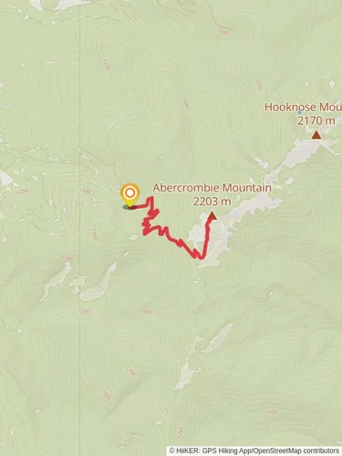
Abercrombie Mountain via Flume Creek Trail
13.0 km
~4 hrs 7 min
922 m
“Explore Abercrombie Mountain's rich history, stunning views, and diverse wildlife on this rewarding 13 km hike.”
Starting your journey near Pend Oreille County, Washington, the Abercrombie Mountain via Flume Creek Trail offers a rewarding 13 km (8 miles) out-and-back hike with an elevation gain of approximately 900 meters (2,950 feet). This trail is rated as medium difficulty, making it suitable for moderately experienced hikers.
### Getting There To reach the trailhead, you can drive to the nearest significant landmark, which is the town of Metaline Falls, Washington. From Metaline Falls, head south on WA-31 S for about 5 miles (8 km) until you reach the Flume Creek Road. Follow this road for approximately 3 miles (4.8 km) to the trailhead parking area. Public transport options are limited in this remote area, so driving is the most reliable way to get there.
### Trail Overview The trail begins with a gentle ascent through a dense forest of Douglas fir and western red cedar. After about 2 km (1.2 miles), you will encounter the first significant landmark, a small wooden bridge crossing Flume Creek. This is a great spot to take a short break and enjoy the serene sounds of the flowing water.
### Mid-Trail Highlights As you continue, the trail becomes steeper, gaining elevation more rapidly. Around the 4 km (2.5 miles) mark, you'll reach a series of switchbacks that offer stunning views of the surrounding Selkirk Mountains. Keep an eye out for wildlife; this area is home to black bears, deer, and a variety of bird species, including the elusive northern goshawk.
### Historical Significance Approximately 6 km (3.7 miles) into the hike, you'll come across remnants of old mining operations. These historical artifacts date back to the late 19th century when the area was actively mined for silver and lead. Take a moment to explore these relics, but be cautious as the structures can be unstable.
### Final Ascent The final 1.5 km (0.9 miles) to the summit of Abercrombie Mountain is the most challenging part of the hike, with a steep incline and rocky terrain. However, the effort is well worth it. Upon reaching the summit, you'll be rewarded with panoramic views of the Selkirk Mountains, the Columbia River, and even glimpses of Canada to the north.
### Navigation and Safety Given the trail's moderate difficulty and remote location, it's advisable to use a reliable navigation tool like HiiKER to ensure you stay on course. The trail is well-marked, but weather conditions can change rapidly, so be prepared with appropriate gear, including layers, a map, and a compass.
### Flora and Fauna Throughout the hike, you'll encounter a diverse range of flora, from lush ferns and mosses in the lower elevations to alpine wildflowers near the summit. The trail is particularly beautiful in late spring and early summer when the wildflowers are in full bloom.
### Return Journey The descent follows the same path, offering a chance to revisit the scenic spots and perhaps notice details you missed on the way up. Take your time and enjoy the tranquility of the forest as you make your way back to the trailhead.
This hike offers a perfect blend of natural beauty, historical intrigue, and physical challenge, making it a must-do for any hiking enthusiast visiting the region.
Reviews
User comments, reviews and discussions about the Abercrombie Mountain via Flume Creek Trail, Washington.
4.0
average rating out of 5
10 rating(s)


