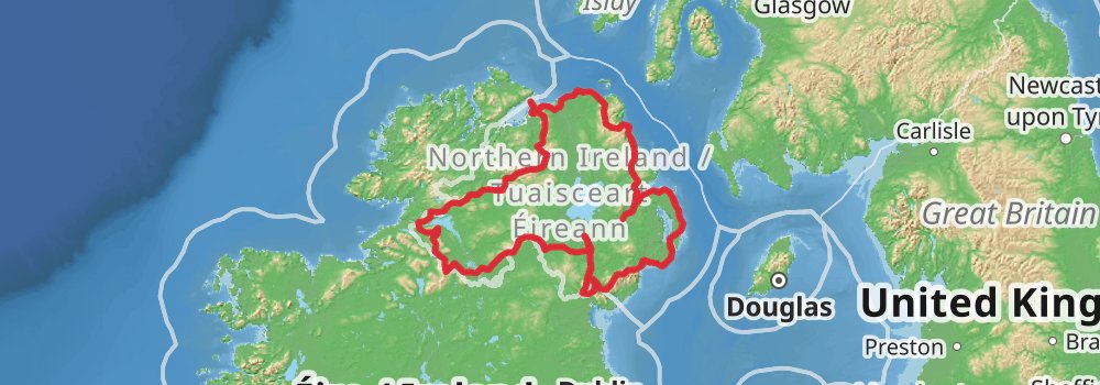
Starting at: Cathedral Quarter, Belfast, County Antrim, BT1 3PB
Ending at: Caproni, Bangor, County Down, BT20 5BS
Distance: 25.8 km
Elevation gain: 272 m
Duration: 05:37:04
View on mapStarting at: County Down, BT20 5AG
Ending at: Millisle, County Down, BT22 2NJ
Distance: 21.9 km
Elevation gain: 177 m
Duration: 04:40:27
View on mapStarting at: Millisle, County Down, BT22 2FF
Ending at: Cloghy, County Down, BT22 1RT
Distance: 19.5 km
Elevation gain: 104 m
Duration: 04:04:03
View on mapStarting at: Cloghy, County Down, BT22 1JA
Ending at: Strangford, County Down, BT30 7LY
Distance: 17.5 km
Elevation gain: 161 m
Duration: 03:46:01
View on mapStarting at: Strangford, County Down, BT30 7LZ
Ending at: Killough, County Down, BT30 7PU
Distance: 21.5 km
Elevation gain: 203 m
Duration: 04:37:45
View on mapStarting at: Killough, County Down
Ending at: Newcastle, County Down, BT33 0RQ
Distance: 31.0 km
Elevation gain: 214 m
Duration: 06:32:51
View on mapStarting at: County Down, BT33 0AG
Ending at: County Down, BT34 5XJ
Distance: 20.1 km
Elevation gain: 755 m
Duration: 05:17:06
View on mapStarting at: Kilcoo, County Down, BT34 5XZ
Distance: 21.6 km
Elevation gain: 455 m
Duration: 05:04:34
View on mapStarting at: County Down, BT34 3NT
Ending at: Killean, County Armagh, BT35 8GP
Distance: 20.0 km
Elevation gain: 298 m
Duration: 04:29:37
View on mapStarting at: County Armagh, BT34 2FJ
Ending at: Forkhill, County Armagh, BT35 9RP
Distance: 21.7 km
Elevation gain: 521 m
Duration: 05:12:57
View on mapStarting at: Forkhill, County Armagh, BT35 8TD
Ending at: Bessbrook, County Armagh, BT35 7LX
Distance: 25.1 km
Elevation gain: 725 m
Duration: 06:13:28
View on mapStarting at: Bessbrook, County Armagh, BT35 6PR
Ending at: Poyntzpass, County Armagh, BT63 6LT
Distance: 20.7 km
Elevation gain: 95 m
Duration: 04:17:32
View on mapStarting at: County Armagh, BT63 6BP
Distance: 25.4 km
Elevation gain: 365 m
Duration: 05:41:35
View on mapStarting at: Armagh, County Armagh, BT61 9AL
Ending at: Caledon, County Tyrone, BT68 4TZ
Distance: 19.5 km
Elevation gain: 264 m
Duration: 04:20:47
View on mapStarting at: Caledon, County Tyrone
Distance: 16.3 km
Elevation gain: 166 m
Duration: 03:32:26
View on mapStarting at: Aughnacloy, County Tyrone
Ending at: Sheskin Electoral Division, County Monaghan
Distance: 28.2 km
Elevation gain: 553 m
Duration: 06:33:34
View on mapStarting at: County Monaghan
Ending at: County Fermanagh, BT92 7AT
Distance: 24.2 km
Elevation gain: 613 m
Duration: 05:51:28
View on mapStarting at: Magheraveely, County Fermanagh, BT92 7BS
Ending at: County Fermanagh, BT92 0JQ
Distance: 22.6 km
Elevation gain: 241 m
Duration: 04:55:37
View on mapStarting at: County Fermanagh, BT92 0EQ
Ending at: County Fermanagh, BT92 1DJ
Distance: 29.0 km
Elevation gain: 387 m
Duration: 06:26:52
View on mapStarting at: Arney, County Fermanagh, BT74 9FH
Distance: 17.2 km
Elevation gain: 317 m
Duration: 03:57:56
View on mapStarting at: Belcoo, County Fermanagh, BT93 5FB
Ending at: County Fermanagh, BT93 6AR
Distance: 19.9 km
Elevation gain: 395 m
Duration: 04:38:36
View on mapStarting at: County Fermanagh
Ending at: Belleek, County Fermanagh, BT93 3FL
Distance: 24.6 km
Elevation gain: 305 m
Duration: 05:26:03
View on mapStarting at: Belleek, County Fermanagh, BT93 3FX
Ending at: Templecarn, County Donegal
Distance: 30.2 km
Elevation gain: 301 m
Duration: 06:32:52
View on mapStarting at: County Donegal
Ending at: County Fermanagh, BT93 1AJ
Distance: 19.8 km
Elevation gain: 270 m
Duration: 04:24:52
View on mapStarting at: County Tyrone, BT93 1BS
Ending at: County Tyrone, BT78 4PX
Distance: 23.0 km
Elevation gain: 413 m
Duration: 05:17:12
View on mapStarting at: Drumquin, County Tyrone, BT78 4SB
Ending at: County Tyrone, BT78 5RA
Distance: 17.5 km
Elevation gain: 470 m
Duration: 04:17:30
View on mapStarting at: Newtownstewart, County Tyrone, BT78 5NW
Ending at: Gortin, County Tyrone, BT79 8NJ
Distance: 21.9 km
Elevation gain: 626 m
Duration: 05:25:07
View on mapStarting at: Gortin, County Tyrone, BT79 8PQ
Ending at: County Tyrone, BT79 8LT
Distance: 21.3 km
Elevation gain: 429 m
Duration: 04:58:34
View on mapStarting at: County Tyrone
Ending at: Dungiven, County Londonderry, BT47 4RS
Distance: 36.4 km
Elevation gain: 923 m
Duration: 08:48:35
View on mapStarting at: County Londonderry, BT47 4SE
Distance: 22.5 km
Elevation gain: 727 m
Duration: 05:42:46
View on map