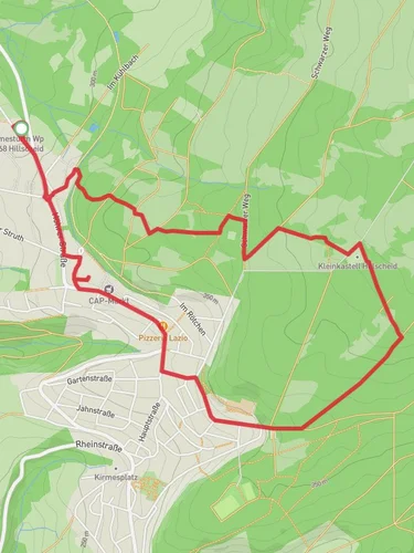
11.1 km
~2 hrs 39 min
255 m
“Experience the Koeppel via Koeppelweg 2 trail's scenic beauty and historical richness on an 11-kilometer loop.”
Starting near Westerwaldkreis, Germany, the Koeppel via Koeppelweg 2 trail is a scenic loop that spans approximately 11 kilometers (around 6.8 miles) with an elevation gain of about 200 meters (656 feet). This medium-difficulty trail offers a blend of natural beauty and historical significance, making it a rewarding experience for hikers.
### Getting There To reach the trailhead, you can drive or use public transport. If driving, set your GPS to Westerwaldkreis, Germany, and look for parking options near the trailhead. For those using public transport, the nearest significant landmark is Montabaur, which is well-connected by train. From Montabaur, you can take a local bus or taxi to the trailhead.
### Trail Navigation For navigation, it is highly recommended to use the HiiKER app, which provides detailed maps and real-time updates. The trail is well-marked, but having a reliable navigation tool will enhance your hiking experience.
### Trail Highlights #### Nature and Wildlife The trail meanders through dense forests and open meadows, offering a diverse range of flora and fauna. Keep an eye out for native wildlife such as deer, foxes, and various bird species. The forested sections are particularly lush, with towering trees providing ample shade and a serene atmosphere.
#### Landmarks and Scenic Views One of the most significant landmarks along the trail is the Koeppel Tower, located roughly halfway through the loop. This observation tower offers panoramic views of the surrounding Westerwald region. The climb to the top is well worth the effort, providing a perfect spot for a rest and some photography.
#### Historical Significance The Westerwald region has a rich history, and this trail passes through areas that have been inhabited for centuries. You may come across old stone walls and remnants of ancient settlements. The area was also significant during various historical periods, including the Roman era and the Middle Ages.
### Trail Sections #### Initial Ascent The trail begins with a gentle ascent, gaining about 100 meters (328 feet) in elevation over the first 3 kilometers (1.86 miles). This section is relatively easy and serves as a good warm-up.
#### Mid-Trail Plateau After the initial climb, the trail levels out, offering a more relaxed hike through open meadows and forested areas. This section is ideal for spotting wildlife and enjoying the natural beauty of the region.
#### Final Descent The last part of the trail involves a descent back to the starting point, losing the remaining 100 meters (328 feet) in elevation over the final 3 kilometers (1.86 miles). This section can be a bit steep, so watch your footing, especially if the ground is wet.
### Preparation Tips - Footwear: Sturdy hiking boots are recommended due to the varied terrain. - Weather: Check the weather forecast before heading out, as conditions can change rapidly. - Supplies: Bring enough water and snacks, as there are no facilities along the trail. - Clothing: Dress in layers to accommodate changing temperatures, especially if you plan to climb the Koeppel Tower.
By following these guidelines and using the HiiKER app for navigation, you'll be well-prepared to enjoy the Koeppel via Koeppelweg 2 trail in all its natural and historical splendor.
Reviews
User comments, reviews and discussions about the Koeppel via Koeppelweg 2, Germany.
0.0
average rating out of 5
0 rating(s)


