12.3 km
~3 hrs 9 min
420 m
“Embark on the Wacholder Kyll Weg for a scenic, moderate hike through Vulkaneifel's volcanic landscapes and rich history.”
Starting near the picturesque region of Vulkaneifel in Germany, this 12 km (approximately 7.5 miles) loop trail offers a moderate challenge with an elevation gain of around 400 meters (about 1,312 feet). The trailhead is conveniently accessible by car or public transport. If you're driving, you can park near the village of Birresborn, which is the closest significant landmark. For those using public transport, take a train to the Birresborn station, which is well-connected to major cities like Cologne and Trier.
### Trail Overview
The Wacholder Kyll Weg is a captivating journey through the heart of the Vulkaneifel region, renowned for its volcanic landscapes and rich biodiversity. The trail meanders through dense forests, open meadows, and along the serene Kyll River, offering a diverse range of scenery and experiences.
### Key Landmarks and Points of Interest
Birresborn Village: Starting your hike from Birresborn, you'll immediately notice the quaint charm of this small village. It's worth taking a moment to explore its historic buildings and perhaps grab a snack before you set off.
Kyll River: As you follow the trail, you'll soon encounter the Kyll River. This tranquil waterway is a perfect spot for a short break, where you can enjoy the soothing sounds of flowing water and perhaps spot some local wildlife, such as kingfishers and herons.
Juniper Heathlands: One of the most unique features of this trail is the juniper heathlands. These rare ecosystems are home to a variety of plant species, including the eponymous juniper bushes. The heathlands are particularly stunning in late summer when the heather is in full bloom, painting the landscape in shades of purple and pink.
Vulkaneifel Geopark: The trail also takes you through parts of the Vulkaneifel Geopark, an area of significant geological interest. Here, you can observe ancient volcanic formations and learn about the region's fiery past. Informational plaques along the way provide fascinating insights into the geological history of the area.
### Flora and Fauna
The Wacholder Kyll Weg is a haven for nature enthusiasts. The mixed woodlands are home to a variety of tree species, including oak, beech, and pine. In the spring and summer months, the forest floor is carpeted with wildflowers, adding a splash of color to your hike.
Wildlife is abundant, with deer, foxes, and wild boar frequently spotted along the trail. Birdwatchers will also be delighted by the variety of species that inhabit the area, from common songbirds to birds of prey like hawks and eagles.
### Navigation and Safety
For navigation, it's highly recommended to use the HiiKER app, which provides detailed maps and real-time updates to ensure you stay on track. The trail is well-marked, but having a reliable navigation tool can enhance your hiking experience and provide peace of mind.
### Historical Significance
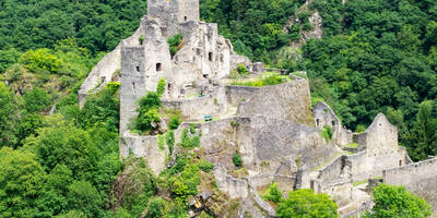
The Vulkaneifel region is steeped in history, with evidence of human settlement dating back to prehistoric times. Along the trail, you'll come across remnants of ancient Roman roads and medieval fortifications, offering a glimpse into the area's rich past. The juniper heathlands themselves have been maintained through traditional land management practices that date back centuries, highlighting the deep connection between the local communities and their natural environment.
### Getting There
To reach the trailhead, drive to Birresborn, where ample parking is available. If you're using public transport, take a train to the Birresborn station. From there, it's a short walk to the start of the trail. The village is well-signposted, making it easy to find your way.
Embark on this trail to experience the natural beauty and historical richness of the Vulkaneifel region, all while enjoying a moderately challenging hike that rewards you with stunning vistas and a deep sense of tranquility.

Reviews
User comments, reviews and discussions about the Wacholder Kyll Weg, Germany.
5.0
average rating out of 5
2 rating(s)