9.9 km
~2 hrs 23 min
240 m
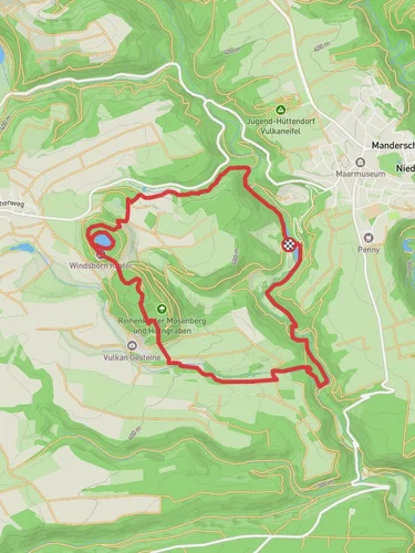
“Discover Vulkaneifel's volcanic wonders on this 10 km loop, blending natural beauty and historical intrigue.”
Starting near the picturesque town of Vulkaneifel, Germany, the Speicherbach via VulkaMaar Pfad trail offers a captivating 10 km (6.2 miles) loop with an elevation gain of approximately 200 meters (656 feet). This medium-difficulty trail is perfect for those looking to immerse themselves in the unique volcanic landscape of the Eifel region.
### Getting There To reach the trailhead, you can drive to Vulkaneifel, where ample parking is available near the starting point. If you prefer public transport, take a train to the nearest major station, Gerolstein, and then a local bus to Vulkaneifel. The bus service is reliable and offers a scenic route through the rolling hills and quaint villages of the region.
### Trail Highlights The trail begins with a gentle ascent through lush forests, where you can expect to see a variety of native flora and fauna. Keep an eye out for deer and wild boar, which are common in this area. The first significant landmark is the Pulvermaar, one of the deepest volcanic lakes in the Eifel, located about 3 km (1.9 miles) into the hike. This serene lake, formed by volcanic activity, offers a perfect spot for a short break and some stunning photo opportunities.
### Historical Significance As you continue, you'll come across remnants of ancient Roman settlements, providing a glimpse into the region's rich history. The Eifel region has been inhabited for thousands of years, and its volcanic soil has made it a fertile area for agriculture and settlement. Look for informational plaques along the trail that offer insights into the historical significance of these sites.
### Navigation and Terrain The trail is well-marked, but it's always a good idea to have a reliable navigation tool like HiiKER to ensure you stay on track. The terrain varies from forest paths to open meadows, with some rocky sections that require careful footing. Around the 6 km (3.7 miles) mark, you'll reach the highest point of the trail, offering panoramic views of the surrounding volcanic landscape.
### Flora and Fauna The descent takes you through a diverse range of ecosystems, from dense woodlands to open fields. In spring and summer, the meadows are alive with wildflowers, attracting a variety of butterflies and bees. Birdwatchers will also find plenty to enjoy, with species like the European robin and the black woodpecker frequently spotted.
### Final Stretch As you near the end of the loop, the trail follows the Speicherbach stream, providing a tranquil setting to wind down your hike. The gentle babbling of the stream and the dappled sunlight filtering through the trees create a peaceful atmosphere, perfect for reflecting on your journey.
### Practical Tips - Wear sturdy hiking boots, as some sections can be rocky and uneven. - Bring plenty of water and snacks, especially during warmer months. - Check the weather forecast before you go, as the trail can be slippery after rain. - Use HiiKER for real-time navigation and updates on trail conditions.
This trail offers a perfect blend of natural beauty, historical intrigue, and moderate physical challenge, making it a must-visit for any hiking enthusiast exploring the Vulkaneifel region.
Reviews
User comments, reviews and discussions about the Speicherbach via VulkaMaar Pfad, Germany.
5.0
average rating out of 5
4 rating(s)


