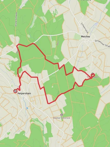
13.4 km
~3 hrs 12 min
316 m
“The 13 km Mehlbacher Teich Feldatal via Heinzmanntour trail offers diverse landscapes, historical landmarks, and abundant wildlife.”
Starting near Vogelsbergkreis, Germany, the Mehlbacher Teich Feldatal via Heinzmanntour is a loop trail that spans approximately 13 kilometers (8 miles) with an elevation gain of around 300 meters (984 feet). This medium-difficulty trail offers a blend of natural beauty, historical landmarks, and diverse wildlife, making it a rewarding experience for hikers.
### Getting There To reach the trailhead, you can drive or use public transport. If driving, set your GPS to Vogelsbergkreis, Germany, and look for parking near the starting point. For those using public transport, the nearest significant landmark is the town of Lauterbach (Hess), which is well-connected by train. From Lauterbach, you can take a local bus or taxi to the trailhead.
### Trail Overview The trail begins near Vogelsbergkreis and quickly immerses you in the lush landscapes of the Vogelsberg region. The initial part of the hike is relatively gentle, allowing you to warm up as you traverse through dense forests and open meadows.
### Key Landmarks and Points of Interest - Mehlbacher Teich: About 3 kilometers (1.86 miles) into the hike, you'll reach Mehlbacher Teich, a serene pond surrounded by woodland. This is a great spot for a short break and some bird-watching. - Feldatal: As you continue, you'll enter the Feldatal area, known for its rolling hills and picturesque valleys. The elevation gain here is gradual, making it manageable for most hikers. - Heinzmanntour: Around the halfway mark, you'll join the Heinzmanntour section of the trail. This part is slightly more challenging, with steeper inclines and rocky terrain. However, the effort is well worth it for the panoramic views of the surrounding countryside.
### Flora and Fauna The trail is rich in biodiversity. You'll encounter a variety of plant species, from towering beech and oak trees to colorful wildflowers. Wildlife is abundant, with chances to spot deer, foxes, and a variety of bird species, including woodpeckers and owls.
### Historical Significance The Vogelsberg region has a rich history dating back to the medieval period. As you hike, you'll come across remnants of old stone walls and possibly even ancient farmsteads. The area was historically significant for its iron ore mining, and you might notice some old mining equipment or informational plaques detailing this aspect of local history.
### Navigation and Safety Given the trail's moderate difficulty, it's advisable to use a reliable navigation tool like HiiKER to stay on track. The trail is well-marked, but having a digital map can be helpful, especially in the more remote sections. Wear sturdy hiking boots, bring plenty of water, and be prepared for sudden weather changes, as the region can be unpredictable.
### Final Stretch The last few kilometers of the trail take you through more open landscapes, offering a gentle descent back to the starting point. This section provides a relaxing end to your hike, with ample opportunities to take in the scenic views and reflect on the journey.
Whether you're a seasoned hiker or a nature enthusiast, the Mehlbacher Teich Feldatal via Heinzmanntour offers a fulfilling experience that combines natural beauty, historical intrigue, and a touch of adventure.
Reviews
User comments, reviews and discussions about the Mehlbacher Teich Feldatal via Heinzmanntour, Germany.
5.0
average rating out of 5
4 rating(s)


