4.8 km
~1 hrs 10 min
129 m
“Explore Tübingen's scenic 5 km trail, blending vibrant nature and rich history for a perfect hike.”
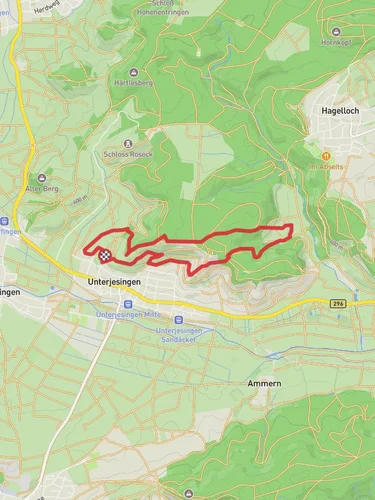
Starting near the picturesque town of Tübingen, Germany, this 5 km (approximately 3.1 miles) loop trail offers a delightful mix of natural beauty and historical intrigue. With an elevation gain of around 100 meters (328 feet), the trail is rated as medium difficulty, making it accessible for most hikers with a moderate level of fitness.
### Getting There To reach the trailhead, you can either drive or use public transport. If you're driving, Tübingen is well-connected by road, and there are several parking options available in the town. For those using public transport, Tübingen is accessible via train from major cities like Stuttgart. From the Tübingen Hauptbahnhof (main train station), you can take a local bus to the trailhead area. The nearest significant landmark to the trailhead is the Tübingen Castle (Schloss Hohentübingen), which is a short walk away.
### Trail Navigation For navigation, it's highly recommended to use the HiiKER app, which provides detailed maps and real-time updates to ensure you stay on track.
### Trail Highlights
#### Nature and Wildlife As you embark on this loop trail, you'll be greeted by a variety of landscapes, from dense forests to open meadows. The trail is particularly beautiful in the spring and autumn when the foliage is at its most vibrant. Keep an eye out for local wildlife, including deer, foxes, and a variety of bird species. The diverse flora includes ancient oak and beech trees, as well as a plethora of wildflowers that add splashes of color to your hike.
#### Historical Significance One of the most captivating aspects of this trail is its historical significance. Tübingen itself is a town rich in history, dating back to the 11th century. As you hike, you'll come across remnants of medieval structures and old farmhouses that tell the story of the region's past. The trail also offers stunning views of the Tübingen Castle, a Renaissance-era fortress that now houses part of the University of Tübingen.
### Points of Interest
#### Tübingen Castle (Schloss Hohentübingen) Approximately 1 km (0.6 miles) into the hike, you'll find yourself near the Tübingen Castle. This historic site offers panoramic views of the town and the surrounding countryside. It's worth taking a short detour to explore the castle grounds and perhaps even visit the museum inside.
#### Gratweg Ridge As you continue, you'll reach the Gratweg Ridge, a highlight of the trail. This section offers breathtaking views of the Swabian Jura and the Neckar Valley. The ridge is about 2.5 km (1.5 miles) into the hike and is the highest point of the trail, providing a perfect spot for a rest and some photography.
### Trail Conditions and Safety The trail is well-marked and maintained, but it's always wise to be prepared for varying conditions. Wear sturdy hiking boots, especially after rain, as some sections can be slippery. Bring plenty of water and snacks, as there are no facilities along the trail. Mobile reception is generally good, but it's always a good idea to let someone know your plans before you set out.
### Final Stretch The last part of the loop takes you through a serene forested area before gradually descending back towards Tübingen. This section is relatively easy and allows you to cool down as you make your way back to the trailhead.
This trail offers a perfect blend of natural beauty, historical landmarks, and moderate physical challenge, making it a must-visit for anyone in the Tübingen area.
Reviews
User comments, reviews and discussions about the Tuebingen and Gratweg, Germany.
5.0
average rating out of 5
2 rating(s)


