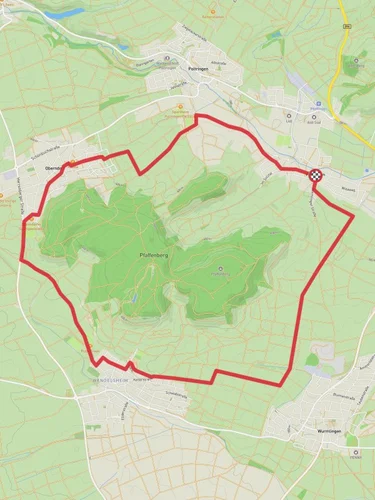
5.9 km
~1 hrs 39 min
285 m
“Explore Tübingen's scenic landscapes and historical landmarks on the delightful 6 km Bayler Kap and Muerle trail.”
Starting near the picturesque town of Tübingen, Germany, the Bayler Kap and Muerle via Unterjesinger Wengertwegle trail offers a delightful 6 km (approximately 3.7 miles) loop with an elevation gain of around 200 meters (656 feet). This medium-difficulty hike is perfect for those looking to explore the natural beauty and historical richness of the region.
### Getting There To reach the trailhead, you can either drive or use public transport. If driving, head towards Tübingen and look for parking near the Unterjesingen area. For those using public transport, take a train or bus to Tübingen Hauptbahnhof (main station). From there, local buses can take you closer to Unterjesingen, where the trail begins.
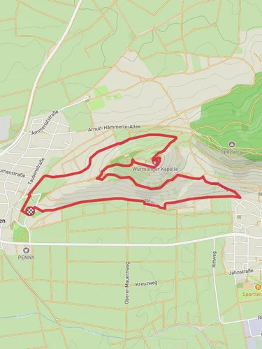
### Trail Overview The trail starts near Unterjesingen, a charming village known for its vineyards and scenic landscapes. As you begin your hike, you'll be greeted by the lush greenery and rolling hills that characterize this part of Germany. The trail is well-marked, but it's always a good idea to have a reliable navigation tool like HiiKER to ensure you stay on track.
### Key Landmarks and Points of Interest - Unterjesinger Wengertwegle: The initial part of the trail takes you through the Unterjesinger Wengertwegle, a path that winds through vineyards. This area is particularly beautiful in the late spring and early summer when the vines are lush and green. - Bayler Kap: About 2 km (1.2 miles) into the hike, you'll reach Bayler Kap, a small chapel with historical significance. This spot offers a great place to take a break and enjoy the panoramic views of the surrounding countryside. - Muerle: Continuing on, you'll come across Muerle, a quaint area known for its traditional Swabian houses and serene atmosphere. This section of the trail is relatively flat, making it a nice contrast to the initial climb.
### Flora and Fauna The trail is rich in biodiversity. Keep an eye out for local wildlife such as deer, foxes, and a variety of bird species. The flora is equally impressive, with wildflowers dotting the landscape, especially in the spring and summer months.
### Historical Significance Tübingen and its surrounding areas have a deep historical background. The region has been inhabited since the Roman times, and you'll find remnants of this history along the trail. The Bayler Kap chapel, for instance, dates back several centuries and serves as a testament to the area's long-standing cultural heritage.
### Practical Tips - Footwear: Given the elevation gain and varied terrain, sturdy hiking boots are recommended. - Weather: The weather can be unpredictable, so it's wise to bring a waterproof jacket and check the forecast before heading out. - Water and Snacks: There are no facilities along the trail, so make sure to bring enough water and snacks to keep you energized.
### Navigation While the trail is well-marked, using HiiKER can provide additional peace of mind, especially if you're unfamiliar with the area. The app offers detailed maps and real-time tracking to help you navigate the trail with ease.
This hike offers a perfect blend of natural beauty, historical landmarks, and a moderate challenge, making it a rewarding experience for any outdoor enthusiast.

Reviews
User comments, reviews and discussions about the Bayler Kap and Muerle via Unterjesinger Wengertwegle, Germany.
5.0
average rating out of 5
4 rating(s)