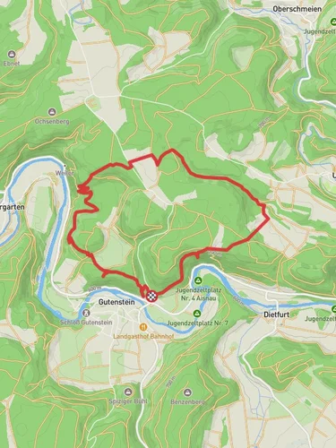
9.4 km
~2 hrs 29 min
370 m
“Explore Sigmaringen’s natural beauty and historical landmarks on a captivating 9 km loop trail.”
Starting near the picturesque town of Sigmaringen, Germany, the Kaenzele, Teufelsbruecke, and Donau Loop offers a captivating 9 km (5.6 miles) journey with an elevation gain of around 300 meters (984 feet). This medium-difficulty loop trail is perfect for those looking to explore the natural beauty and historical richness of the region.
### Getting There To reach the trailhead, you can either drive or use public transport. If driving, head towards Sigmaringen and look for parking options near the town center. For those using public transport, Sigmaringen is well-connected by train. The nearest train station is Sigmaringen Bahnhof, from where you can take a short walk or a local bus to the trailhead.
### Trail Highlights
#### Kaenzele Starting from the trailhead, the initial section takes you through lush forests and gently rolling hills. The first significant landmark is Kaenzele, a scenic viewpoint offering panoramic views of the surrounding landscape. This spot is perfect for a short break and some photography. The elevation gain here is gradual, making it a comfortable start to your hike.
#### Teufelsbruecke Continuing on, you will encounter the Teufelsbruecke, or "Devil's Bridge." This historic stone bridge spans a narrow gorge and is steeped in local legends. According to folklore, the bridge was built by the devil himself in exchange for the soul of the first being to cross it. Today, it stands as a testament to medieval engineering and offers a unique photo opportunity. The trail around this area becomes a bit steeper, so be prepared for a moderate climb.
#### Donau River As you proceed, the trail descends towards the Donau (Danube) River. This section is relatively flat and runs parallel to the river, providing serene views of the water and the chance to spot local wildlife such as ducks, herons, and even the occasional beaver. The riverbanks are lined with a variety of flora, including wildflowers and ancient trees, making it a delightful stretch for nature enthusiasts.
### Navigation and Safety The trail is well-marked, but it's always a good idea to have a reliable navigation tool. HiiKER is an excellent app for this purpose, offering detailed maps and real-time tracking to ensure you stay on course.
### Historical Significance Sigmaringen itself is a town rich in history, with the Sigmaringen Castle being a notable landmark. The castle, visible from various points along the trail, dates back to the 11th century and has been the residence of the Hohenzollern family. The trail also passes by several smaller historical sites, including old mills and remnants of medieval fortifications.
### Wildlife and Flora The diverse ecosystem along the trail includes a variety of bird species, small mammals, and an array of plant life. Keep an eye out for red squirrels darting through the trees and listen for the melodic calls of songbirds. The forested areas are home to oak, beech, and pine trees, while the riverbanks feature willows and alders.
### Final Stretch The final part of the loop brings you back towards Sigmaringen, with a gentle descent that offers a relaxing end to your hike. As you approach the town, you'll pass through open meadows and small patches of woodland, providing a last glimpse of the natural beauty that characterizes this trail.
This 9 km loop is a perfect blend of natural beauty, historical intrigue, and moderate physical challenge, making it an ideal choice for hikers of all levels.
Reviews
User comments, reviews and discussions about the Kaenzele, Teufelsbruecke and Donau Loop, Germany.
4.0
average rating out of 5
3 rating(s)


