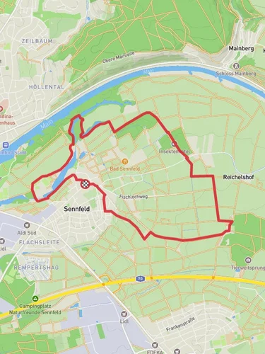
Schweinfurt Stadt to Schonungen via Main via Am Nadeloehr
4.8 km
~58 min
10 m
“Discover Schweinfurt's scenic trail blending urban charm, historical intrigue, and lush landscapes perfect for all explorers.”
Starting near the charming town of Schweinfurt, Germany, this 5 km (approximately 3.1 miles) point-to-point trail takes you to Schonungen via Main and Am Nadeloehr. The trailhead is conveniently located near Schweinfurt, which is accessible by both public transport and car. If you're traveling by train, Schweinfurt Hauptbahnhof is the nearest major station, and from there, local buses or a short taxi ride can get you to the trailhead. For those driving, there are parking facilities available near the starting point.
### Trail Overview
The trail is relatively flat with an elevation gain of around 0 meters, making it accessible for hikers of varying skill levels, though it is rated as medium difficulty due to its length and terrain. The path meanders through picturesque landscapes, offering a blend of urban and natural scenery.
### Key Landmarks and Points of Interest
Schweinfurt Stadt: The trail begins in Schweinfurt, a town known for its rich industrial history and beautiful architecture. As you start your hike, take a moment to appreciate the historical buildings and the Main River that flows through the town.
Main River: Following the Main River, the trail offers stunning views of the waterway. The riverbanks are lined with lush greenery, making it a perfect spot for birdwatching. Keep an eye out for local species such as swans, ducks, and various songbirds.
Am Nadeloehr: As you continue, you'll pass through Am Nadeloehr, a narrow passage that adds a unique element to the hike. This section is particularly scenic, with dense foliage and the occasional glimpse of wildlife like deer and foxes.
### Historical Significance
The region around Schweinfurt has a deep historical significance, particularly in the context of World War II. Schweinfurt was a major target due to its ball bearing factories, which were crucial to the war effort. Today, the town has transformed into a peaceful area with numerous historical markers and museums that commemorate its past.
### Navigation and Safety
For navigation, it's highly recommended to use the HiiKER app, which provides detailed maps and real-time updates. The trail is well-marked, but having a reliable navigation tool ensures you stay on track and can explore additional points of interest along the way.
### Flora and Fauna
The trail is rich in biodiversity. Depending on the season, you might encounter blooming wildflowers, dense forests, and a variety of wildlife. Spring and summer are particularly vibrant, with the landscape bursting into color and life.
### Getting to the Trailhead
By Public Transport: From Schweinfurt Hauptbahnhof, local buses or a short taxi ride will get you to the trailhead. Check the local bus schedules for the most convenient routes.
By Car: If you're driving, there are parking facilities available near the starting point. The nearest significant landmark for GPS navigation is the Schweinfurt Rathaus (Town Hall).
This trail offers a delightful mix of natural beauty and historical intrigue, making it a rewarding experience for any hiker.
Reviews
User comments, reviews and discussions about the Schweinfurt Stadt to Schonungen via Main via Am Nadeloehr, Germany.
5.0
average rating out of 5
3 rating(s)


