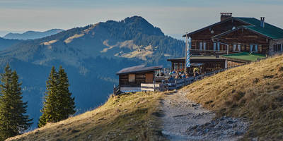
Altenberger Pinge and Geisingberg Loop via Evasteig - Altenberg
10.1 km
~2 hrs 26 min
258 m
“Explore natural beauty and historical intrigue on Germany's 10 km Sächsische Schweiz-Osterzgebirge loop trail.”
Starting near the picturesque region of Sächsische Schweiz-Osterzgebirge in Germany, this 10 km (approximately 6.2 miles) loop trail offers a delightful mix of natural beauty and historical intrigue. With an elevation gain of around 200 meters (656 feet), the trail is rated as medium difficulty, making it suitable for moderately experienced hikers.
### Getting There To reach the trailhead, you can either drive or use public transport. If driving, set your GPS to Altenberg, a charming town in the Sächsische Schweiz-Osterzgebirge district. For those using public transport, take a train to Altenberg (Erzgebirge) station. From there, it's a short bus ride to the trailhead near the town center.
### Trail Highlights
#### Altenberger Pinge The trail begins with a visit to the Altenberger Pinge, a massive sinkhole formed by centuries of mining activity. This geological marvel is a stark reminder of the region's rich mining history. The sinkhole is approximately 1.5 km (0.9 miles) from the trailhead, and the path leading to it is relatively flat, making for an easy start.
#### Evasteig Path Continuing along the Evasteig path, you'll encounter a variety of flora and fauna. The dense forests are home to deer, foxes, and a plethora of bird species. Keep an eye out for the European Green Woodpecker and the Eurasian Jay, both commonly spotted in this area. The trail here is moderately inclined, gaining about 50 meters (164 feet) in elevation over the next 2 km (1.2 miles).
#### Geisingberg Summit At around the 5 km (3.1 miles) mark, you'll reach the Geisingberg summit. Standing at 824 meters (2,703 feet) above sea level, this peak offers panoramic views of the Ore Mountains and the surrounding valleys. The climb to the summit is the most challenging part of the hike, with a steep ascent of approximately 100 meters (328 feet) over 1 km (0.6 miles). However, the breathtaking vistas make the effort well worth it.
#### Historical Significance The region is steeped in history, particularly related to its mining heritage. Altenberg has been a center for tin mining since the 15th century. The remnants of old mining equipment and structures can still be seen along the trail, offering a glimpse into the past. Informational plaques provide context and enrich the hiking experience.
### Navigation and Safety For navigation, it's highly recommended to use the HiiKER app, which provides detailed maps and real-time updates. The trail is well-marked, but having a reliable navigation tool ensures you stay on course.
### Wildlife and Flora The trail traverses through mixed forests, meadows, and rocky outcrops. In spring and summer, the meadows are adorned with wildflowers like the European Columbine and the Common Hepatica. The forested sections are dominated by beech, oak, and spruce trees. Wildlife is abundant, so be prepared for possible encounters with deer and smaller mammals.
### Final Stretch The descent from Geisingberg is gradual, allowing you to enjoy the serene landscape as you make your way back. The final 3 km (1.9 miles) of the trail are relatively flat, passing through lush meadows and small streams before looping back to the starting point near Altenberg.
This trail offers a balanced mix of natural beauty, historical significance, and moderate physical challenge, making it a rewarding experience for any hiker.
Reviews
User comments, reviews and discussions about the Altenberger Pinge and Geisingberg Loop via Evasteig - Altenberg, Germany.
5.0
average rating out of 5
4 rating(s)


