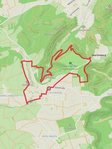
13.3 km
~3 hrs 5 min
253 m
“The Grenzblickweg Loop near Saarlouis offers scenic views, historical landmarks, and a rewarding hiking experience.”
Starting near Saarlouis, Germany, the Grenzblickweg Loop is a captivating 13 km (approximately 8 miles) trail with an elevation gain of around 200 meters (656 feet). This loop trail offers a medium difficulty rating, making it suitable for moderately experienced hikers.
### Getting There To reach the trailhead, you can drive or use public transport. If driving, set your GPS to Saarlouis, and look for parking options near the town center. For those using public transport, Saarlouis is well-connected by train and bus services. The nearest significant landmark is the Saarlouis Hauptbahnhof (main train station), from where you can either walk or take a local bus to the trailhead.
### Trail Overview The Grenzblickweg Loop is a well-marked trail that takes you through a variety of landscapes, including dense forests, open meadows, and scenic viewpoints. The trail is known for its panoramic views of the surrounding countryside and the historical significance of the region.
### Key Landmarks and Points of Interest
#### Saar Polygon Approximately 3 km (1.9 miles) into the hike, you'll come across the Saar Polygon, a striking steel structure that offers a 360-degree view of the Saarland region. This landmark is not only a visual treat but also a symbol of the region's industrial heritage.
#### Forested Sections Around the 5 km (3.1 miles) mark, the trail takes you through dense forested areas. These sections are rich in biodiversity, offering opportunities to spot local wildlife such as deer, foxes, and a variety of bird species. The forest canopy provides ample shade, making this part of the hike particularly pleasant during warmer months.
#### Historical Significance The region around Saarlouis has a rich history, particularly related to its strategic importance in various European conflicts. As you hike, you'll notice remnants of old fortifications and bunkers, especially near the 8 km (5 miles) point. These structures date back to World War II and earlier, offering a glimpse into the past.
### Navigation and Safety The trail is well-marked, but it's always a good idea to have a reliable navigation tool. HiiKER is an excellent app for this purpose, providing detailed maps and real-time updates. Make sure to carry enough water and snacks, as there are limited facilities along the trail.
### Flora and Fauna The Grenzblickweg Loop is a haven for nature enthusiasts. In spring and summer, the meadows are adorned with wildflowers, while the autumn months bring a spectacular display of fall foliage. Keep an eye out for local wildlife, including various bird species, small mammals, and occasionally larger animals like deer.
### Final Stretch As you approach the final 2 km (1.2 miles) of the loop, the trail descends gradually, offering more open views of the surrounding countryside. This section is relatively easy, allowing you to cool down and enjoy the last moments of your hike.
The Grenzblickweg Loop near Saarlouis offers a perfect blend of natural beauty, historical landmarks, and moderate physical challenge, making it a rewarding experience for any hiker.
Reviews
User comments, reviews and discussions about the Grenzblickweg Loop, Germany.
0.0
average rating out of 5
0 rating(s)


