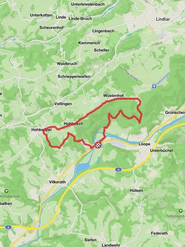
12.3 km
~3 hrs 1 min
341 m
“Explore the diverse beauty and moderate challenges of the 12 km Rund um Vilkerath trail in Germany.”
Starting near Rheinisch-Bergischer Kreis in Germany, this 12 km (approximately 7.5 miles) loop trail offers a delightful mix of natural beauty and moderate physical challenge, with an elevation gain of around 300 meters (approximately 984 feet). The trailhead is conveniently accessible by both public transport and car. If you're taking public transport, the nearest significant landmark is the Vilkerath train station, which is well-connected to the surrounding areas. For those driving, there are parking facilities available near the trailhead.
### Trail Overview
The Rund um Vilkerath trail is a medium-difficulty hike that takes you through a variety of landscapes, including dense forests, open meadows, and charming rural areas. The trail is well-marked, but it's always a good idea to have a reliable navigation tool like HiiKER to ensure you stay on track.
### Key Landmarks and Points of Interest
#### Forested Sections The initial part of the trail takes you through lush, dense forests. These sections are particularly beautiful in the spring and autumn when the foliage is either budding or changing colors. Keep an eye out for local wildlife such as deer, foxes, and a variety of bird species. The forested areas also provide a cool, shaded environment, making this part of the hike quite pleasant even during warmer months.
#### Open Meadows and Farmlands As you progress, the trail opens up into expansive meadows and farmlands. These areas offer panoramic views of the surrounding countryside and are perfect for a short break or picnic. The elevation gain here is gradual, making it a good spot to catch your breath and take in the scenery.
#### Historical Significance The region around Vilkerath has a rich history dating back to medieval times. Along the trail, you may come across old farmhouses and remnants of historical structures. One notable landmark is the Vilkerath Church, which dates back several centuries and is a fine example of local architecture. The church is located approximately halfway through the trail, making it a perfect midpoint for a rest and some exploration.
### Elevation and Terrain
The total elevation gain of around 300 meters (984 feet) is spread out over the 12 km (7.5 miles) distance, making the climbs manageable for most hikers. The terrain varies from well-trodden paths in the forest to grassy tracks in the meadows and some gravel roads. Good hiking boots are recommended to handle the diverse terrain comfortably.
### Wildlife and Flora
The trail is home to a variety of flora and fauna. In the forested sections, you'll find oak, beech, and pine trees, while the meadows are dotted with wildflowers, especially in the spring and summer. Wildlife sightings are common, so keep your camera ready. Birds such as woodpeckers, owls, and various songbirds are frequently spotted, adding to the trail's natural charm.
### Getting There
To reach the trailhead, you can take a train to Vilkerath station, which is the nearest significant landmark. From the station, it's a short walk to the start of the trail. If you're driving, set your GPS to Vilkerath, Rheinisch-Bergischer Kreis, and look for parking signs near the trailhead.
### Preparation Tips
Given the medium difficulty rating, it's advisable to bring sufficient water, snacks, and a basic first-aid kit. Weather can be unpredictable, so check the forecast and dress in layers. A map or a navigation tool like HiiKER will be invaluable for staying on course and making the most of your hike.
This trail offers a well-rounded hiking experience with its mix of natural beauty, moderate physical challenge, and historical landmarks. Whether you're a seasoned hiker or someone looking to explore the German countryside, the Rund um Vilkerath trail is a rewarding choice.
Reviews
User comments, reviews and discussions about the Rund um Vilkerath, Germany.
0.0
average rating out of 5
0 rating(s)


