8.0 km
~1 hrs 58 min
223 m
“The Ringelsteinweg offers a scenic 8 km hike through forests, medieval ruins, and panoramic viewpoints in Rhein-Sieg-Kreis.”
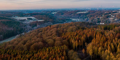
Starting near Rhein-Sieg-Kreis, Germany, the Ringelsteinweg is an 8 km (approximately 5 miles) loop trail with an elevation gain of around 200 meters (656 feet). This medium-difficulty trail offers a blend of natural beauty and historical intrigue, making it a rewarding experience for hikers.
### Getting There To reach the trailhead, you can drive or use public transport. If driving, set your GPS to the nearest known address: Rhein-Sieg-Kreis, Germany. For those using public transport, take a train to the nearest major station, such as Bonn Hauptbahnhof, and then a local bus to Rhein-Sieg-Kreis. From there, it's a short walk to the trailhead.
### Trail Overview The trail begins with a gentle ascent through a mixed forest, where you'll be surrounded by towering beech and oak trees. The initial 2 km (1.2 miles) offer a gradual climb, gaining about 100 meters (328 feet) in elevation. This section is relatively easy and provides a good warm-up for the more challenging parts ahead.
### Historical Significance Around the 3 km (1.8 miles) mark, you'll come across the ruins of Ringelstein Castle. This medieval fortress dates back to the 12th century and offers a glimpse into the region's rich history. Take some time to explore the ruins and imagine the lives of those who once inhabited this stronghold. Information boards provide historical context, making it a fascinating stop.
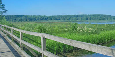
### Nature and Wildlife As you continue, the trail meanders through a diverse landscape. Keep an eye out for local wildlife such as deer, foxes, and various bird species. The forest floor is often carpeted with wildflowers in the spring, adding a splash of color to your hike. The next 2 km (1.2 miles) are relatively flat, allowing you to enjoy the scenery without too much exertion.
### Navigation For navigation, it's highly recommended to use the HiiKER app, which provides detailed maps and real-time updates. This will ensure you stay on track and can easily find points of interest along the way.
### Scenic Views At around the 6 km (3.7 miles) mark, the trail opens up to a panoramic viewpoint. Here, you can take in sweeping views of the surrounding countryside, including the rolling hills and distant villages. This is a perfect spot for a break and some photos.
### Final Stretch The last 2 km (1.2 miles) of the trail involve a descent back to the starting point. This section can be a bit steep, so watch your footing, especially if the ground is wet. The trail winds through a dense forest, providing a serene and peaceful end to your hike.
### Practical Tips - Wear sturdy hiking boots, as some sections can be rocky and uneven. - Bring enough water and snacks, especially if you plan to spend time exploring the castle ruins. - Check the weather forecast before heading out, as conditions can change rapidly. - Use the HiiKER app for navigation and to stay updated on trail conditions.
This trail offers a perfect blend of natural beauty, historical landmarks, and moderate physical challenge, making it an excellent choice for a day hike.

Reviews
User comments, reviews and discussions about the Ringelsteinweg, Germany.
0.0
average rating out of 5
0 rating(s)