10.6 km
~3 hrs 1 min
548 m
“The Rundwanderweg Dossenheim offers a captivating 11 km hike with diverse landscapes, historical landmarks, and rich wildlife.”
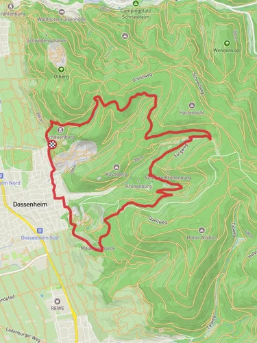
Starting your hike near Rhein-Neckar-Kreis, Germany, the Rundwanderweg Dossenheim is a captivating loop trail that spans approximately 11 km (6.8 miles) with an elevation gain of around 500 meters (1,640 feet). This medium-difficulty trail offers a blend of natural beauty, historical landmarks, and diverse wildlife, making it a rewarding experience for hikers.
### Getting There To reach the trailhead, you can either drive or use public transport. If driving, set your GPS to Dossenheim, a town in the Rhein-Neckar-Kreis district. There are parking facilities available near the trailhead. For those using public transport, take a train to Heidelberg and then a local bus to Dossenheim. The bus stop closest to the trailhead is "Dossenheim Süd," which is a short walk from the starting point.
### Trail Overview The trail begins in the charming town of Dossenheim, known for its picturesque landscapes and historical significance. As you start your hike, you'll immediately notice the well-marked paths that guide you through a variety of terrains, including dense forests, open meadows, and rocky outcrops.
### Key Landmarks and Sections
#### Dossenheimer Steinbrüche Approximately 2 km (1.2 miles) into the hike, you'll come across the Dossenheimer Steinbrüche, an old quarry that offers a glimpse into the region's industrial past. The quarry is now a protected area, home to various plant species and a haven for birdwatchers.
#### Aussichtspunkt Weiße Hütte Around the 5 km (3.1 miles) mark, you'll reach the Aussichtspunkt Weiße Hütte, a popular viewpoint. Here, you can take a break and enjoy panoramic views of the Rhine Valley and the Odenwald forest. This spot is perfect for photography enthusiasts looking to capture the scenic beauty of the area.
#### Nature and Wildlife As you continue, the trail meanders through lush forests where you might encounter local wildlife such as deer, foxes, and a variety of bird species. The flora is equally diverse, with oak, beech, and pine trees dominating the landscape. During spring and summer, the trail is adorned with wildflowers, adding a splash of color to your hike.
### Historical Significance The region around Dossenheim has a rich history dating back to Roman times. The trail itself passes by several historical markers and ruins, including remnants of old Roman roads and medieval fortifications. These landmarks offer a fascinating insight into the area's past and are well worth a brief stop.
### Navigation and Safety For navigation, it's highly recommended to use the HiiKER app, which provides detailed maps and real-time updates. The trail is generally well-marked, but having a reliable navigation tool ensures you stay on track.
### Final Stretch The last few kilometers of the trail take you through more open landscapes, gradually descending back towards Dossenheim. This section is less strenuous, allowing you to relax and reflect on the diverse experiences the trail has offered.
By the time you complete the loop, you'll have traversed a variety of landscapes, encountered historical landmarks, and enjoyed some of the best views the region has to offer. Whether you're a seasoned hiker or a casual walker, the Rundwanderweg Dossenheim provides a fulfilling and enriching outdoor adventure.
Reviews
User comments, reviews and discussions about the Rundwanderweg Dossenheim, Germany.
5.0
average rating out of 5
6 rating(s)


