14.2 km
~3 hrs 52 min
621 m
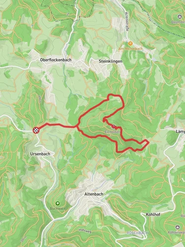
“This 14 km loop trail near Rhein-Neckar-Kreis combines lush forests, historical landmarks, and panoramic views.”
Starting near Rhein-Neckar-Kreis, Germany, this 14 km (8.7 miles) loop trail offers a moderate challenge with an elevation gain of approximately 600 meters (1,968 feet). The trailhead is conveniently accessible by both public transport and car. If you're using public transport, you can take a train to the nearest station in Wiesloch-Walldorf and then a bus to the trailhead. For those driving, parking is available near the starting point.### Initial Ascent and HansenbuehlThe trail begins with a gradual ascent through a dense forest, providing a serene start to your hike. As you climb towards Hansenbuehl, you'll gain about 300 meters (984 feet) in elevation over the first 5 km (3.1 miles). The forest is rich with native flora, including beech and oak trees, and you might spot wildlife such as deer and various bird species. Keep an eye out for the occasional wild boar tracks as well.### Reaching HansenbuehlUpon reaching Hansenbuehl, you'll be rewarded with panoramic views of the surrounding countryside. This area is known for its historical significance, as it was once a strategic lookout point during various regional conflicts. The remnants of old fortifications can still be seen, offering a glimpse into the past. Take a moment to rest and enjoy the scenery before continuing.### Descent and Camino InclusoThe descent from Hansenbuehl is gradual and takes you through a mix of open meadows and forested areas. After about 3 km (1.9 miles), you'll reach the Camino Incluso, a well-marked path that is part of a larger network of trails in the region. This section is relatively flat and allows for a more leisurely pace. The Camino Incluso is known for its well-preserved Roman road sections, adding a layer of historical intrigue to your hike.### Eichelberg AscentAs you approach Eichelberg, the trail begins to climb again, gaining another 200 meters (656 feet) in elevation over the next 3 km (1.9 miles). This section is more challenging, with steeper inclines and rocky terrain. However, the effort is well worth it as you reach the summit of Eichelberg. Here, you'll find a small clearing with a bench, perfect for a short break. The views from Eichelberg are stunning, offering a different perspective of the Rhein-Neckar-Kreis region.### Final Descent and ReturnThe final descent takes you back through a lush forest, gradually losing elevation over the last 3 km (1.9 miles) of the trail. This section is less strenuous, allowing you to enjoy the natural beauty of the area. As you near the end of the loop, you'll pass by several small streams and possibly encounter more wildlife.### Navigation and SafetyFor navigation, it's highly recommended to use the HiiKER app, which provides detailed maps and real-time updates. The trail is well-marked, but having a reliable navigation tool will ensure you stay on track. Always carry enough water, snacks, and a basic first-aid kit. Weather can change rapidly, so be prepared with appropriate clothing and gear.This trail offers a mix of natural beauty, historical landmarks, and moderate physical challenge, making it a rewarding experience for hikers of all levels.
Reviews
User comments, reviews and discussions about the Hansenbuehl and Eichelberg via Camino Incluso, Germany.
5.0
average rating out of 5
5 rating(s)
Loading reviews...


