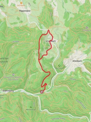
6.9 km
~1 hrs 47 min
239 m
“The Eichelberg Loop offers a 7 km journey through forests, historic sites, and scenic viewpoints for moderate hikers.”
Starting your hike near the Rhein-Neckar-Kreis in Germany, the Eichelberg Loop offers a delightful 7 km (approximately 4.3 miles) journey with an elevation gain of around 200 meters (656 feet). This loop trail is rated as medium difficulty, making it suitable for moderately experienced hikers.### Getting There
To reach the trailhead, you can drive or use public transport. If driving, set your GPS to the nearest known address: Eichelberg, 74889 Sinsheim, Germany. For those using public transport, take a train to Sinsheim and then a local bus towards Eichelberg. The trailhead is conveniently located near the village, making it easily accessible.### Trail Navigation
For navigation, it is highly recommended to use the HiiKER app, which provides detailed maps and real-time updates to ensure you stay on track.### Trail Highlights
As you embark on the Eichelberg Loop, you'll be greeted by a mix of dense forests and open meadows. The trail begins with a gentle ascent, allowing you to ease into the hike. After about 1 km (0.6 miles), you'll reach a scenic viewpoint offering panoramic views of the surrounding countryside. This is a great spot to take a break and enjoy the landscape.### Flora and Fauna
The trail is rich in biodiversity. Keep an eye out for native wildlife such as deer, foxes, and a variety of bird species. The forested sections are home to oak, beech, and pine trees, providing ample shade and a serene atmosphere.### Historical Significance
The region around Rhein-Neckar-Kreis is steeped in history. As you hike, you'll come across several historical markers and ruins. Around the 4 km (2.5 miles) mark, you'll find the remnants of an old watchtower, which dates back to the medieval period. This tower was part of a network used for regional defense and communication.### Midpoint Rest Area
At approximately 3.5 km (2.2 miles), there's a designated rest area equipped with benches and informational plaques about the local ecosystem and history. This is an ideal spot to refuel with some snacks and water.### Final Stretch
The last 2 km (1.2 miles) of the trail involve a gradual descent back towards the trailhead. This section is particularly scenic, with open fields and distant views of the village of Eichelberg. As you near the end, you'll pass through a small orchard, which is especially beautiful in the spring when the trees are in bloom.### Practical Tips
- Wear sturdy hiking boots as the trail can be uneven in places.
- Bring sufficient water and snacks, especially if you plan to take your time exploring the historical sites.
- Check the weather forecast before heading out, as the trail can be slippery after rain.
- Use the HiiKER app for real-time navigation and updates.The Eichelberg Loop offers a balanced mix of natural beauty, historical intrigue, and moderate physical challenge, making it a rewarding hike for those looking to explore the scenic and historical richness of the Rhein-Neckar-Kreis region.
Reviews
User comments, reviews and discussions about the Eichelberg Loop, Germany.
5.0
average rating out of 5
6 rating(s)
Loading reviews...


