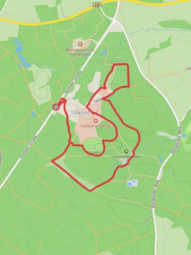
12.0 km
~2 hrs 36 min
120 m
“This 12 km trail near Rendsburg-Eckernförde offers natural beauty, wildlife, and historical intrigue for moderate hikers.”
Starting near Rendsburg-Eckernförde in Germany, this 12 km (approximately 7.5 miles) loop trail offers a delightful mix of natural beauty and historical intrigue. With an elevation gain of around 100 meters (328 feet), the trail is rated as medium difficulty, making it accessible for most hikers with a moderate level of fitness.
### Getting There To reach the trailhead, you can either drive or use public transport. If driving, head towards the vicinity of Rendsburg-Eckernförde, where parking is available near the starting point. For those using public transport, the nearest significant landmark is the Rendsburg train station. From there, local buses or a short taxi ride can take you to the trailhead.
### Trail Navigation For navigation, it's highly recommended to use the HiiKER app, which provides detailed maps and real-time updates. This will help ensure you stay on track and can easily find your way back if you decide to explore any of the side paths.
### Trail Highlights As you embark on the trail, you'll first encounter a serene forested area, rich with towering trees and a lush undergrowth. This section is relatively flat, allowing you to ease into the hike. About 2 km (1.2 miles) in, you'll come across the first of several "Waldhuetten" or forest huts. These rustic shelters offer a great spot to take a break and soak in the tranquil surroundings.
### Flora and Fauna The trail is a haven for nature enthusiasts. Keep an eye out for native wildlife such as deer, foxes, and a variety of bird species. The flora is equally impressive, with seasonal wildflowers adding splashes of color to the verdant landscape. In the spring and summer months, the forest floor is often carpeted with blooming flowers, making it a picturesque setting for photography.
### Historical Significance Around the 5 km (3.1 miles) mark, you'll reach Boxberg, a site of historical significance. This area was once a strategic lookout point and has remnants of ancient fortifications. Informational plaques provide insights into the history of the region, making it a fascinating stop for history buffs.
### Midpoint and Elevation The midpoint of the trail is where you'll encounter the most significant elevation gain. As you ascend, the trail becomes a bit steeper, but the effort is rewarded with panoramic views of the surrounding countryside. This section is approximately 6 km (3.7 miles) into the hike and offers a perfect spot for a picnic.
### Return Loop The return loop takes you through a different section of the forest, offering new scenery and experiences. You'll pass by additional Waldhuetten, each uniquely situated to provide different perspectives of the forest. The final stretch of the trail is a gentle descent, leading you back to the starting point.
### Practical Tips - Wear sturdy hiking boots, as some sections can be uneven. - Bring plenty of water and snacks, especially if you plan to picnic at the midpoint. - Check the weather forecast before heading out, as the trail can become slippery in wet conditions. - Use the HiiKER app for real-time navigation and updates.
This trail offers a perfect blend of natural beauty, wildlife, and historical intrigue, making it a rewarding experience for any hiker.
Reviews
User comments, reviews and discussions about the Boxberg via Wanderroute Waldhuetten, Germany.
4.0
average rating out of 5
3 rating(s)


