14.3 km
~3 hrs 53 min
622 m
“Explore Ostalbkreis' scenic 14 km loop, combining lush forests, historical sites, and rewarding climbs.”
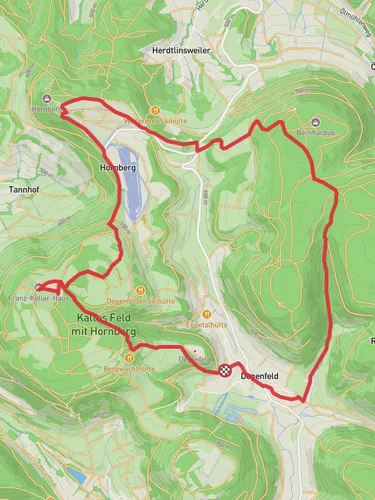
Starting near the picturesque town of Ostalbkreis in Germany, this 14 km (approximately 8.7 miles) loop trail offers a delightful mix of natural beauty, historical landmarks, and moderate physical challenge. With an elevation gain of around 600 meters (approximately 1,970 feet), hikers can expect a rewarding experience that combines both ascents and descents.
### Getting There To reach the trailhead, you can either drive or use public transport. If driving, set your GPS to the nearest known address: Bahnhofstraße 1, 73430 Aalen, Germany. From there, it's a short drive to the trailhead. For those using public transport, take a train to Aalen Hauptbahnhof. From the station, local buses or a short taxi ride will get you to the starting point.
### Trail Overview The loop begins with a gentle ascent through lush forests, providing ample shade and a serene atmosphere. Early on, you'll encounter the Degenfeld area, known for its charming village and historical significance. The trail here is well-marked, but it's always a good idea to have the HiiKER app for navigation.
### Degenfeld to Hornberg As you continue, the trail gradually climbs towards Hornberg. This section is approximately 5 km (3.1 miles) into the hike and features a mix of forested paths and open meadows. The elevation gain here is steady but manageable, making it a good warm-up for the more challenging sections ahead. Keep an eye out for local wildlife, including deer and various bird species.
### Hornberg to Galgenberg The next segment takes you from Hornberg to Galgenberg, covering another 4 km (2.5 miles). This part of the trail is particularly scenic, offering panoramic views of the surrounding valleys and hills. The elevation gain becomes more noticeable here, with some steeper sections that will test your endurance. Galgenberg itself is steeped in history, once serving as a site for medieval executions, hence its name which translates to "Gallows Hill."
### Galgenberg to Trailhead The final stretch of the loop brings you back to the trailhead, covering the remaining 5 km (3.1 miles). This section is mostly downhill, allowing you to enjoy a more relaxed pace as you descend through mixed forests and past small streams. The trail here is well-maintained, but be cautious of loose rocks and roots, especially after rain.
### Points of Interest - Degenfeld Village: A quaint village with historical buildings and a peaceful atmosphere. - Hornberg: Offers stunning views and is a great spot for a short break. - Galgenberg: Rich in history, this area provides a unique glimpse into the region's past.
### Wildlife and Flora The trail is home to a variety of wildlife, including deer, foxes, and numerous bird species. The flora is equally diverse, with dense forests of beech and oak, interspersed with wildflowers and ferns.
### Preparation Tips - Footwear: Sturdy hiking boots are recommended due to the varied terrain. - Water: Carry at least 2 liters (0.5 gallons) of water, as there are limited refill points. - Weather: Check the weather forecast before you go; the trail can be slippery after rain. - Navigation: Use the HiiKER app for real-time navigation and updates.
This loop trail offers a perfect blend of natural beauty, moderate physical challenge, and historical intrigue, making it a must-visit for any hiking enthusiast.
Reviews
User comments, reviews and discussions about the Degenfeld, Hornberg and Galgenberg Loop, Germany.
5.0
average rating out of 5
2 rating(s)


