6.7 km
~1 hrs 44 min
242 m
“Immerse yourself in the serene beauty and rich history of the Unnenberg Rundweg's 7 km loop in Germany.”
Starting near the picturesque town of Oberbergischer Kreis in Germany, the Unnenberg Rundweg is a delightful 7 km (approximately 4.35 miles) loop trail that offers a moderate challenge with an elevation gain of around 200 meters (656 feet). This trail is perfect for those looking to immerse themselves in the serene beauty of the German countryside while enjoying a moderately challenging hike.
### Getting There
To reach the trailhead, you can either drive or use public transport. If you're driving, set your GPS to Oberbergischer Kreis, and you'll find ample parking near the trailhead. For those using public transport, take a train to Gummersbach station, and from there, a local bus can take you to the vicinity of the trailhead. The nearest significant landmark to the trailhead is the Unnenberg Tower, which is a well-known observation tower in the area.
### Trail Navigation
The Unnenberg Rundweg is well-marked, but it's always a good idea to have a reliable navigation tool. The HiiKER app is highly recommended for this purpose, as it provides detailed maps and real-time tracking to ensure you stay on the right path.
### Trail Highlights
#### Nature and Wildlife
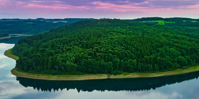
As you embark on the Unnenberg Rundweg, you'll be greeted by lush forests and rolling hills. The trail meanders through dense woodlands, where you can spot a variety of wildlife, including deer, foxes, and numerous bird species. The forest canopy provides ample shade, making it a pleasant hike even on warmer days.
#### Significant Landmarks
One of the most notable landmarks along the trail is the Unnenberg Tower. Approximately 3 km (1.86 miles) into the hike, you'll reach this observation tower, which offers panoramic views of the surrounding landscape. On a clear day, you can see as far as the Cologne Cathedral. The tower itself has historical significance, having been built in the early 20th century as a lookout point.
#### Historical Significance
The region around Oberbergischer Kreis has a rich history dating back to medieval times. The trail passes by several old farmhouses and remnants of ancient settlements, providing a glimpse into the area's past. Keep an eye out for informational plaques along the way that offer insights into the historical context of these sites.
### Trail Conditions and Safety
The trail is well-maintained, but it's always wise to be prepared for varying conditions. The terrain includes a mix of dirt paths, gravel, and some rocky sections. Good hiking boots are recommended to navigate these diverse surfaces comfortably. The elevation gain is gradual, but there are a few steeper sections that may require a bit more effort.
### Flora and Fauna
Throughout the hike, you'll encounter a diverse range of flora. In spring and summer, the trail is adorned with wildflowers, adding a splash of color to the verdant landscape. The forest is predominantly composed of beech and oak trees, which provide a habitat for various woodland creatures.
### Final Stretch
As you near the end of the loop, the trail descends gently back towards the starting point. This section offers a more open landscape, with meadows and fields providing a contrast to the dense forest you traversed earlier. The final kilometer (0.62 miles) is relatively flat, allowing you to cool down and reflect on the natural beauty you've experienced.
The Unnenberg Rundweg is a rewarding hike that combines natural beauty, historical landmarks, and a moderate physical challenge. Whether you're a seasoned hiker or a casual walker, this trail offers something for everyone.
Reviews
User comments, reviews and discussions about the Unnenberg Rundweg, Germany.
5.0
average rating out of 5
1 rating(s)


