12.9 km
~2 hrs 54 min
200 m
“Explore Silbertalsperre's 13 km loop, blending lush landscapes, historical landmarks, and diverse wildlife for a rewarding hike.”
Starting near Oberbergischer Kreis, Germany, the Silbertalsperre via Hambüchen and Schevelinger Weg trail is a 13 km (8 miles) loop with an elevation gain of approximately 200 meters (656 feet). This medium-difficulty trail offers a mix of natural beauty, historical landmarks, and diverse wildlife, making it a rewarding experience for hikers.
### Getting There To reach the trailhead, you can drive or use public transport. If driving, set your GPS to Oberbergischer Kreis, Germany, and look for parking near the Silbertalsperre reservoir. For public transport, take a train to Gummersbach station, then a bus to the nearest stop at Marienheide, from where you can walk to the trailhead.
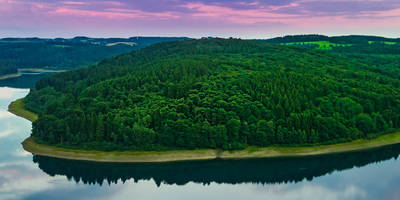
### Trail Overview The trail begins near the Silbertalsperre reservoir, a significant landmark in the region. The reservoir itself is a beautiful sight, surrounded by lush forests and offering serene water views. As you start your hike, you'll follow well-marked paths that guide you through dense woodlands and open meadows.
### Key Sections and Landmarks - Hambüchen: About 3 km (1.8 miles) into the hike, you'll reach Hambüchen. This area is known for its picturesque landscapes and offers a great spot for a short break. The elevation gain here is gradual, making it a comfortable start to your journey. - Schevelinger Weg: Continuing on, you'll encounter Schevelinger Weg around the 7 km (4.3 miles) mark. This section of the trail is slightly more challenging due to its steeper inclines, but it rewards hikers with stunning panoramic views of the surrounding countryside. Keep an eye out for local wildlife, including deer and various bird species.
### Historical Significance The region around Oberbergischer Kreis has a rich history, with several historical landmarks along the trail. One notable site is the old mill near Hambüchen, which dates back to the 18th century. This mill played a crucial role in the local economy and is a fascinating glimpse into the area's past.
### Navigation and Safety For navigation, it's recommended to use the HiiKER app, which provides detailed maps and real-time updates. The trail is well-marked, but having a reliable navigation tool ensures you stay on track.
### Flora and Fauna The trail is abundant with diverse flora and fauna. In spring and summer, the meadows are filled with wildflowers, while the forests are home to a variety of trees, including oak, beech, and pine. Wildlife sightings are common, so keep your camera ready for deer, foxes, and a variety of bird species.
### Final Stretch As you loop back towards the Silbertalsperre reservoir, the trail descends gently, offering a relaxing end to your hike. The final 3 km (1.8 miles) are relatively flat, allowing you to enjoy the tranquil surroundings and reflect on the journey.
This trail offers a perfect blend of natural beauty, historical intrigue, and moderate physical challenge, making it an excellent choice for hikers looking to explore the scenic landscapes of Oberbergischer Kreis.
Reviews
User comments, reviews and discussions about the Silbertalsperre via Hambüchen and Schevelinger Weg, Germany.
4.0
average rating out of 5
1 rating(s)


