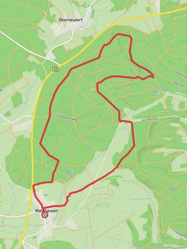
10.0 km
~2 hrs 13 min
143 m
“The Schefflenz Loop is a scenic 10 km trail with historical ruins and panoramic views, perfect for moderate hikers.”
Starting near Neckar-Odenwald-Kreis in Germany, the Schefflenz Loop is a delightful 10 km (6.2 miles) trail with an elevation gain of approximately 100 meters (328 feet). This loop trail is rated as medium difficulty, making it suitable for moderately experienced hikers.
### Getting There To reach the trailhead, you can either drive or use public transport. If you're driving, set your GPS to the vicinity of Neckar-Odenwald-Kreis. For those using public transport, the nearest significant landmark is the town of Mosbach. From Mosbach, you can take a local bus or taxi to the trailhead.
### Trail Overview The Schefflenz Loop offers a variety of landscapes, from dense forests to open meadows. The trail is well-marked, but it's always a good idea to have a reliable navigation tool like HiiKER to ensure you stay on track.
### Key Landmarks and Points of Interest - Schefflenz River: Early in the hike, you'll encounter the Schefflenz River. This serene waterway is perfect for a quick rest stop and some picturesque photos. - Historical Ruins: Around the 4 km (2.5 miles) mark, you'll come across the ruins of an old castle. These ruins date back to the medieval period and offer a glimpse into the region's rich history. - Panoramic Viewpoint: At approximately 6 km (3.7 miles), there's a viewpoint that offers stunning panoramic views of the Odenwald forest and surrounding valleys. This is a great spot for a lunch break and some photography.
### Flora and Fauna The trail is abundant with diverse flora and fauna. In the spring and summer months, you'll find a variety of wildflowers, including orchids and lilies. The forested sections are home to deer, foxes, and a variety of bird species, making it a great trail for wildlife enthusiasts.
### Trail Conditions and Safety The trail is generally well-maintained, but there are some sections with loose rocks and roots, so sturdy hiking boots are recommended. The elevation gain is gradual, but there are a few steeper sections that may require extra caution. Always check the weather forecast before heading out, as the trail can become slippery after rain.
### Navigation and Amenities While the trail is well-marked, having HiiKER on your smartphone will provide additional peace of mind. There are a few benches and picnic tables along the route, but no water sources, so make sure to bring enough water for the entire hike. Public restrooms are available at the trailhead.
### Historical Significance The Neckar-Odenwald-Kreis region has a rich history dating back to Roman times. The area was a significant route for trade and military movements. The ruins you encounter on the trail are remnants of this historical significance, offering a tangible connection to the past.
### Final Stretch As you near the end of the loop, the trail descends gently back towards the starting point. This section is less forested, offering more open views of the surrounding countryside. The final kilometer (0.6 miles) is relatively flat, making for a pleasant and easy finish to your hike.
Reviews
User comments, reviews and discussions about the Schefflenz Loop, Germany.
0.0
average rating out of 5
0 rating(s)


