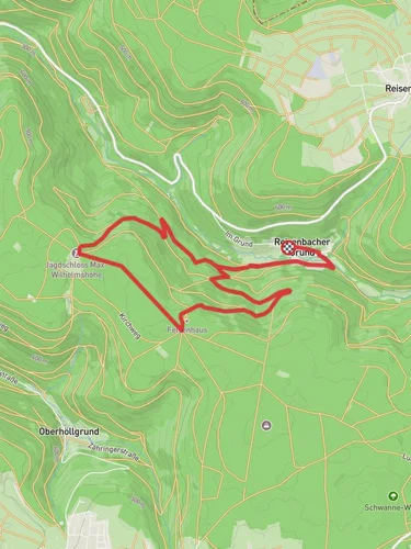
11.2 km
~2 hrs 53 min
399 m
“Discover the Max-Wilhelmshoehe Weg, a trail of scenic beauty and historical charm in Neckar-Odenwald-Kreis.”
Nestled in the picturesque region of Neckar-Odenwald-Kreis, Germany, this 11 km (approximately 6.8 miles) loop trail offers a delightful blend of natural beauty and historical intrigue. With an elevation gain of around 300 meters (about 984 feet), the Max-Wilhelmshoehe Weg is a moderately challenging hike that rewards adventurers with stunning vistas and a rich tapestry of cultural landmarks.
### Getting There
To reach the trailhead, travelers can opt for public transport or drive. If you're using public transport, the nearest major town is Mosbach, which is well-connected by train. From Mosbach, local buses can take you closer to the trailhead. For those driving, the trailhead is accessible via the B27 road, with parking available near the starting point.
### Trail Highlights
Scenic Landscapes and Natural Beauty
As you embark on the Max-Wilhelmshoehe Weg, you'll be greeted by the lush greenery of the Odenwald forest. The trail meanders through dense woodlands, offering a serene escape from urban life. Keep an eye out for native wildlife, including deer and a variety of bird species, which are often spotted along the path. The trail's elevation gain provides several vantage points where you can pause to admire panoramic views of the surrounding countryside.
Historical Significance
The region is steeped in history, and the trail itself is named after Max Wilhelmshöhe, a notable figure in local lore. As you hike, you'll encounter remnants of ancient settlements and historical markers that tell the story of the area's past. One of the most significant landmarks is the ruins of an old castle, which can be found approximately halfway through the loop. These ruins offer a glimpse into the medieval history of the region and provide a perfect spot for a rest and reflection.
Navigation and Safety
The trail is well-marked, but it's always wise to have a reliable navigation tool. HiiKER is an excellent resource for detailed maps and real-time trail updates. The path can be uneven in places, so sturdy hiking boots are recommended. Weather conditions can change rapidly, so pack accordingly with layers and rain gear.
### Practical Tips
The Max-Wilhelmshoehe Weg is best enjoyed during the spring and autumn months when the weather is mild, and the foliage is at its most vibrant. There are no facilities along the trail, so ensure you carry enough water and snacks for the journey. The loop nature of the trail means you'll return to your starting point, making logistics straightforward.
This trail offers a perfect blend of nature and history, making it a must-visit for those exploring the Neckar-Odenwald-Kreis region. Whether you're a seasoned hiker or a curious traveler, the Max-Wilhelmshoehe Weg promises an enriching experience.
Reviews
User comments, reviews and discussions about the Max-Wilhelmshoehe Weg, Germany.
0.0
average rating out of 5
0 rating(s)


