9.8 km
~2 hrs 31 min
332 m
“Explore Saxony's scenic landscapes and historical sites on the captivating 10 km Zipfel Hill Loop.”
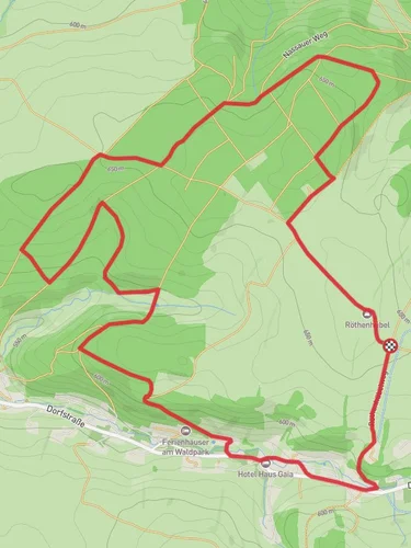
Starting near Mittelsachsen, Germany, the Zipfel Hill Loop via Katzensteinweg is a captivating 10 km (6.2 miles) loop trail with an elevation gain of around 300 meters (984 feet). This medium-difficulty trail offers a blend of natural beauty, historical significance, and a moderately challenging hike that is perfect for those looking to explore the scenic landscapes of Saxony.
### Getting There To reach the trailhead, you can either drive or use public transport. If driving, set your GPS to the nearest significant landmark, which is the town of Mittweida. From Mittweida, follow local roads to the trailhead near Mittelsachsen. For those using public transport, take a train to Mittweida Station. From there, you can catch a local bus or taxi to the trailhead.
### Trail Overview The trail begins with a gentle ascent through dense forests, offering a serene start to your hike. As you progress, the path becomes steeper, leading you to the first significant landmark, the Katzenstein, a striking rock formation that offers panoramic views of the surrounding countryside. This section is approximately 3 km (1.9 miles) into the hike and involves an elevation gain of about 100 meters (328 feet).
### Historical Significance The region around Mittelsachsen is rich in history. During your hike, you'll pass by remnants of old mining operations, a testament to the area's industrial past. These historical sites are well-marked, providing informative plaques that detail the significance of the mining industry in Saxony.
### Flora and Fauna As you continue along the loop, you'll traverse through mixed forests of beech, oak, and pine. Keep an eye out for local wildlife, including deer, foxes, and a variety of bird species. The trail is particularly beautiful in the spring and autumn when the foliage is at its most vibrant.
### Midpoint and Zipfel Hill Around the 5 km (3.1 miles) mark, you'll reach the highest point of the trail, Zipfel Hill. Here, the elevation gain totals approximately 200 meters (656 feet). This is an excellent spot to take a break, enjoy a packed lunch, and soak in the expansive views of the Saxon landscape.
### Descending and Completing the Loop The descent from Zipfel Hill is gradual, winding through more forested areas and open meadows. This section of the trail is less steep, making for a pleasant and leisurely return to the trailhead. Along the way, you'll pass by small streams and possibly encounter local hikers and nature enthusiasts.
### Navigation and Safety For navigation, it's highly recommended to use the HiiKER app, which provides detailed maps and real-time GPS tracking to ensure you stay on course. The trail is well-marked, but having a reliable navigation tool will enhance your hiking experience and provide peace of mind.
### Final Stretch The final stretch of the trail brings you back to the starting point near Mittelsachsen, completing the loop. This last section is relatively flat and easy, allowing you to cool down and reflect on the diverse landscapes and historical sites you've encountered.
This 10 km loop offers a well-rounded hiking experience, combining natural beauty, historical intrigue, and moderate physical challenge. Whether you're a seasoned hiker or a nature enthusiast, the Zipfel Hill Loop via Katzensteinweg is a trail that promises a rewarding adventure.
Reviews
User comments, reviews and discussions about the Zipfel Hill Loop via Katzensteinweg, Germany.
4.0
average rating out of 5
3 rating(s)


