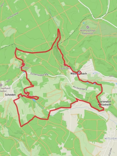
12.3 km
~3 hrs 6 min
386 m
“Explore Teufelsfels, Hoher Fels, and Eulenfels on a 12 km loop of natural beauty and historical intrigue.”
Starting near Merzig-Wadern, Germany, the Teufelsfels, Hoher Fels, and Eulenfels via 2 Taeler Weg trail is a captivating 12 km (7.5 miles) loop with an elevation gain of approximately 300 meters (984 feet). This medium-difficulty trail offers a blend of natural beauty, historical landmarks, and diverse wildlife, making it a rewarding experience for hikers.
### Getting There To reach the trailhead, you can either drive or use public transport. If driving, set your GPS to Merzig-Wadern, and look for parking near the trailhead. For those using public transport, take a train to Merzig station. From there, local buses or a short taxi ride will get you to the starting point.
### Trail Highlights
#### Teufelsfels The first significant landmark you'll encounter is Teufelsfels, or "Devil's Rock." This striking rock formation is steeped in local folklore, with legends suggesting it was a meeting place for witches. The panoramic views from the top are breathtaking, offering a glimpse of the surrounding forest and valleys. The climb to Teufelsfels is moderate, with an elevation gain of about 100 meters (328 feet) over 2 km (1.2 miles).
#### Hoher Fels Continuing along the trail, you'll reach Hoher Fels, another impressive rock formation. This section of the trail is relatively flat, making it a good spot to catch your breath and enjoy the scenery. Hoher Fels is known for its unique geological features, including layers of sedimentary rock that tell a story millions of years in the making. This area is also a hotspot for birdwatching, so keep your binoculars handy.
#### Eulenfels The final major landmark is Eulenfels, or "Owl Rock." This part of the trail involves a steeper climb, with an elevation gain of around 150 meters (492 feet) over 3 km (1.9 miles). The effort is well worth it, as the summit offers stunning views and a sense of accomplishment. Eulenfels is named for the owls that inhabit the area, and if you're lucky, you might spot one.
### Nature and Wildlife The trail meanders through dense forests, open meadows, and rocky outcrops, providing a diverse range of habitats for wildlife. Deer, foxes, and various bird species are commonly seen along the route. The flora is equally diverse, with wildflowers, ferns, and ancient trees adding to the trail's natural beauty.
### Historical Significance The region around Merzig-Wadern has a rich history dating back to Roman times. Along the trail, you'll find remnants of ancient settlements and old stone walls that hint at the area's past. The trail itself has been used for centuries, serving as a route for traders, pilgrims, and locals.
### Navigation To ensure you stay on track, it's advisable to use the HiiKER app, which provides detailed maps and real-time navigation. The trail is well-marked, but having a reliable navigation tool can enhance your hiking experience and provide peace of mind.
### Preparation Given the medium difficulty rating, it's essential to wear sturdy hiking boots and bring plenty of water and snacks. Weather can be unpredictable, so pack a rain jacket and layers. The trail can be muddy in places, especially after rain, so be prepared for varying trail conditions.
This 12 km loop offers a perfect blend of natural beauty, historical intrigue, and physical challenge, making it a must-visit for any hiking enthusiast.
Reviews
User comments, reviews and discussions about the Teufelsfels, Hoher Fels and Eulenfels via 2 Taeler Weg, Germany.
0.0
average rating out of 5
0 rating(s)


